This idea is not yet agreed. This page is part of the thinking behind the Valley of Grace Learning Campus. It is a desk study made from maps, with no visit to the land. The Transformasie Komitee, the national Department of Land Reform (which holds Farm 39 in trust), Theewaterskloof Municipality and Greyton’s residents bodies have not been asked about any of the sites. Please do not share this page publicly yet. It will be tabled with the Learning Campus at the DevForum’s November 2026 meeting.
What the letters in square brackets mean
Facts on this page are followed by a tag that shows where they come from.
- [IC] Independently Corroborated. Confirmed by at least two sources that do not depend on each other, or by an official record such as a Surveyor-General record.
- [MS] Mission-Sourced. Comes from the people putting this idea forward. On this page, that means the study’s own measurements from the national contour map. A surveyor has not checked them.
- [TBV] To Be Verified. Seems likely, but nobody has confirmed it yet.
Statements without a tag are proposals. They describe what the campus could become.
The goal
Find a north-facing slope above the Riviersonderend where an earthship campus for 600 learners can stand clear of floods, with a road to reach it.
Why the campus needs a site study
The Learning Campus page says that no site has been chosen [MS]. Five possible sites were marked on the DevForum’s map of the valley’s land: three on Farm 39 and two on Erf 595 [MS]. Farm 39 covers 4,498.09 hectares [IC] and Erf 595 covers 1,404.89 hectares [IC].
The campus would be built as earthships: low buildings dug into the slope, with a glass front facing north to catch the winter sun and earth packed against the back. Earthships need a slope that faces north and is neither too flat nor too steep. The campus would also need to stay clear of floods, look over the Riviersonderend, and have room for boarding later. A desk study can narrow five sites down before anyone spends money on surveys.
How the study was done
-
The map. The study used one source: the DevForum’s Google Earth map of the valley. That map holds the national contour lines (lines joining points at the same height) from the National Geo-spatial Information office, drawn from aerial photographs taken in 2007 [IC]. It also holds the Surveyor-General boundaries, the river lines, the possible dam sites and the proposed bypass road [MS].
-
The ground. From the contour lines, the study rebuilt the shape of the ground on a 5 metre grid [MS]. It also moved the river lines to the lowest ground in the valley, because the mapped lines are rough [MS]. In places the river moved more than 200 metres [MS].
-
The campus. The study laid out a full campus at each site:
- 600 learners in the day school first (about 5,400 m² of buildings)
- boarding for 600 later (about 12,300 m² more)
- food gardens, courts, water storage and a bus drop-off [MS].
The buildings would follow the contours in rows. The rows are spaced so that each row’s glass front still gets sun at midday on the shortest day of the year [MS]. With a 30% reserve for growth, each campus needs about 9 to 11 hectares [MS].
-
The tests. Each site was first tested against four rules it had to pass. Then it was scored on how well it suits the campus.
The rules every site had to pass
| Rule | What it means |
|---|---|
| Clear of floods | Every building and garden at least 100 metres from a river, at least 10 metres above the riverbed, off the flat valley floor, and outside every possible dam lake |
| On Farm 39 or Erf 595 | Inside one of the two properties, at least 20 metres from its boundary |
| Overlooks the river | At least 200 metres of the Riviersonderend visible from the learning buildings |
| Room for both phases | The day school and the boarding school both fit, on slopes between 3% and 30%, with no two buildings more than 600 metres apart |
The 100 metre distance follows the national rule for building near a river where no flood line has been drawn [TBV]. The study’s flood test is a rough screen. It does not replace a 1-in-100-year flood line drawn by an engineer.
How the sites were scored
| What was scored | Weight | What scores well |
|---|---|---|
| Earthship fit | 35% | Slopes facing north, between 5% and 15%, with long runs along the contour and little digging |
| River view | 20% | A long view of the river, 20 to 80 metres above it, with the river to the north so the view and the sun face the same way |
| Safety margin from floods | 10% | More distance and height above the river than the minimum |
| Road access | 20% | A short, safe link to a road. Sites on the proposed south-bank bypass score highest |
| Other land matters | 15% | Fire risk, shelter from wind, room to grow, distance from the boundary |
What the study found
All five sites pass the four rules [MS]. Option 3 passes only if its bus drop-off is a 20 metre drive-through loop, because there is no flat ground near it for a bus to turn [MS]. In the ranking, 5 is the best possible score.
| Rank | Site | Where | Land | Score out of 5 | In one line |
|---|---|---|---|---|---|
| 1 | Option 1 | South of the river, on the hill between Genadendal and Greyton | Farm 39 | 4.53 [MS] | Faces north over the river, 65 metres above it, close to the proposed bypass |
| 2 | Option 5 | South of the river, opposite Voorstekraal | Farm 39 | 4.05 [MS] | Best facing slope of the five; its lowest gardens sit right at the flood limit |
| 3 | Option 4 | South of the river, near the Krige Road east of Greyton | Erf 595 | 3.97 [MS] | Good ground, but at the flood limits, and only if the river runs where the study puts it |
| 4 | Option 3 | North of the river, east of the Gobos | Erf 595 | 3.49 [MS] | Faces north, but the river lies behind it |
| 5 | Option 2 | North of the river, between Genadendal and Greyton | Farm 39 | 3.09 [MS] | Its only usable slopes face south, which does not suit earthships |
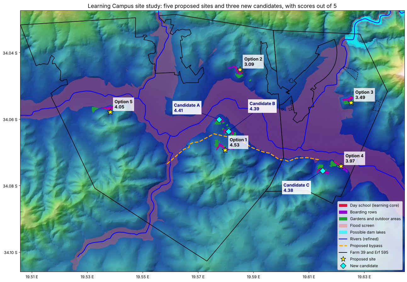
The map shows each site’s campus layout and its score out of 5. Yellow stars are the five proposed sites. Blue diamonds are the three sites the search found (see below). Red is the day school, purple the boarding rows, green the gardens and outdoor areas. The pink band along the rivers is the flood screen.
Option 1 comes first in every test of the study’s assumptions [MS]. These were checked:
- smaller and larger buildings
- 300 boarders in place of 600
- a second storey on the hostels
- giving more weight to earthship fit, or more to road access.
Second place is close [MS]. Options 5 and 4 are less than 0.1 apart. Option 5 moves ahead because it can use an old dirt road from the R406, just south of the river, which once led into Genadendal [MS]. That road would need upgrading.
Site by site
Option 1: on Farm 39, south of the river
The learning buildings would sit in two curved rows on the north shoulder of the hill, about 270 metres above sea level [MS]. That is 65 metres above the river and about 1 kilometre from it [MS]. From there, more than 5 kilometres of the river can be seen, with the river lying to the north [MS]. The boarding rows would step around the hill to the east and west [MS].
A short road of about 250 metres, no steeper than 10%, would link the campus to the proposed bypass [MS]. Drivers at that junction could see about 210 metres west and 240 metres east along the bypass [MS]. A second road out, for emergencies, could join the bypass at a separate point [MS]. In a subsequent phase, a bridge could be built across the river to provide ready access to Greyton and Genadendal, doubling as another escape route.
Option 5: on Farm 39, south of the river
The buildings would sit on the north face of the ridge opposite Voorstekraal, about 18 metres above the river and 360 metres from it [MS]. They would face almost due north, the best of the five [MS]. The ridge behind would shelter the campus from the summer south-easter [MS]. The lowest gardens and the bus drop-off would sit exactly 10 metres above the riverbed, at the limit of the flood rule [MS].
Option 4: on Erf 595, south of the river
The buildings would run along the north foot of a hill near the end of the Krige Road, on gentle slopes [MS]. They would sit only 10 to 11 metres above the riverbed [MS]. The river line on the DevForum’s map runs along the foot of this hill [MS]. The study’s reading of the contours puts the river about 400 metres away, in the middle of the valley floor [MS]. If the mapped line is right, the site fails the 100 metre rule [MS]. A short visit, or an aerial photograph, would settle this.
The nearest safe junction with the bypass is about 2 kilometres from the site, because the ground near the Krige Road end blocks the view along the road [MS].
Option 3: on Erf 595, north of the river
The buildings would sit on a north-facing spur east of the Gobos, above Greyton [MS]. The site is well clear of floods [MS]. The main river lies about 1.8 kilometres to the south, behind the buildings, and only about 1,100 metres of it can be seen [MS]. The slope below the site is long and steep, which would let a veld fire run up towards the buildings [MS].
Option 2: on Farm 39, north of the river
The only slopes near this site that can hold the campus face south, towards the river [MS]. An earthship there would have to face its glass either uphill into its own earth bank, or away from the winter sun. For that reason it ranks last, although it is safe from floods and has a good view.
Three more sites from a search
After scoring the five proposed sites, the study searched all of Farm 39 and Erf 595 for places they might have missed [MS]. It looked for north-facing slopes of the right steepness that pass the flood and boundary rules. Then it tried to fit the full campus at 110 places across that land [MS]. Places within 500 metres of a proposed site were left out, so that the search would find new ground [MS].
The full campus fitted at 67 places, and 42 of them passed every rule [MS]. Nine more fitted, but their buildings stood on or beside the line of the proposed bypass, so they were left out [MS]. The three best are below. Each scores higher than Options 2, 3, 4 and 5, and none scores higher than Option 1 [MS].
| Site | Where | Land | Score out of 5 | In one line |
|---|---|---|---|---|
| Candidate A | The north tip of the low spur below Option 1, near the river | Farm 39 | 4.41 [MS] | The longest river view found: more than 6 kilometres |
| Candidate B | The middle of the same spur, just north of the proposed bypass | Farm 39 | 4.39 [MS] | The easiest building ground found, with the least digging |
| Candidate C | Higher up the hill where Option 4 stands, about 600 metres west of it | Erf 595 | 4.38 [MS] | Option 4’s view without its flood problem |
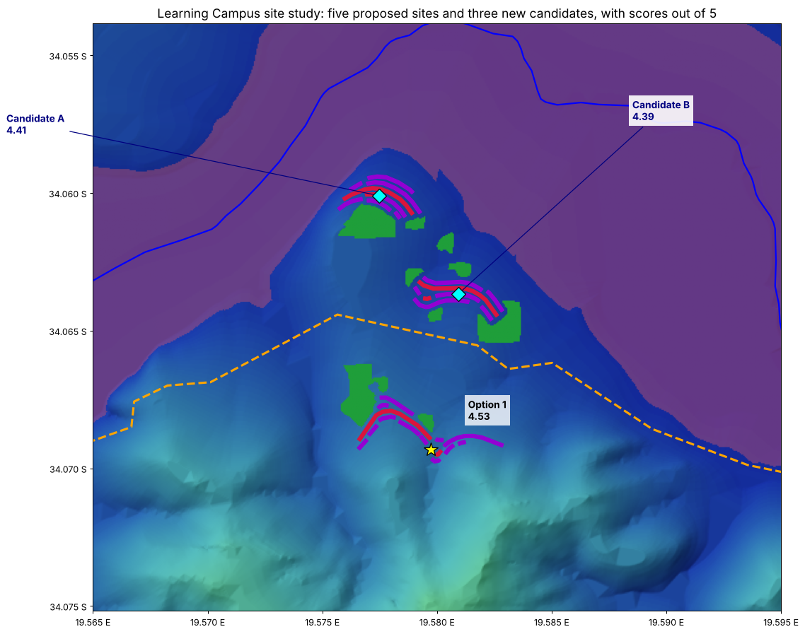
Candidates A and B sit on the low spur that runs north from Option 1’s hill towards the river. The proposed bypass (orange) runs between them and Option 1.
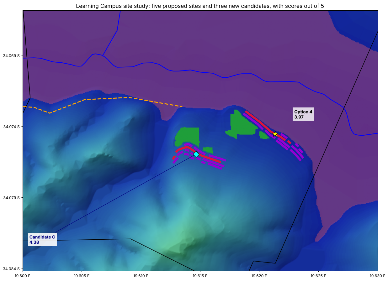
Candidate C sits higher up the same hill as Option 4.
Candidate A
The buildings would wrap the north tip of the spur, about 230 metres above sea level [MS]. That is 27 metres above the river and about 300 metres from it [MS]. More than 6 kilometres of the river can be seen from the learning buildings, the most of any site in the study [MS]. The whole campus would fit within about 330 metres [MS]. A road of about 340 metres would join the bypass at much the same point as Option 1’s road [MS]. The site is open to wind from both the south-east and the north-west [MS].
Candidate B
The buildings would sit on the gentlest north-facing slope in the study, about 9% [MS]. The rows could be long, and the digging would be the least of any site [MS]. The learning buildings would stand about 28 metres above the river and more than 700 metres from it [MS]. The nearest building would be about 100 metres from the proposed bypass [MS]. A boarding school that close to a road for heavy trucks would need careful design for noise and for keeping children off the road.
Candidates A and B are only 500 metres apart and use the same spur. They are two ways of using one piece of land, and only one of them would be built.
Candidate C
The buildings would stand about 245 metres above sea level, on the same hill as Option 4 but about 40 metres higher [MS]. That puts them nearly 50 metres above the river [MS]. Measured from either river line, they are more than 400 metres from the river [MS]. Option 4’s two problems, being close to the flood limits and depending on where the river runs, do not arise here. Like Option 4, its nearest safe junction with the bypass is about 2 kilometres away [MS].
What the search shows
Option 1 and Candidates A and B all stand on one hill, between Genadendal and Greyton, south of the river and beside the proposed bypass [MS]. The search points to this hill as the strongest ground in the study area. The proposed bypass also runs across some of this ground. If the campus goes ahead there, the campus and the road would need to be planned together.
The proposed bypass road
The study also checked the proposed south-bank bypass, wherever the campus goes. About 945 metres of the 5.7 kilometre route falls inside the flood screen [MS]:
- the first 550 metres at the R406 end, where it crosses a stream and its flat ground [MS]
- about 190 metres near the middle, a little less than 10 metres above the river [MS]
- the last 285 metres at the Krige Road end, as low as 6 metres above the river [MS].
These sections would need bridges or culverts designed for floods, and permission to work near a river [TBV].
The study then drew a new line for the road that keeps clear of the campus sites and needs about half the earthworks. It is set out on A South-Bank Bypass Road.
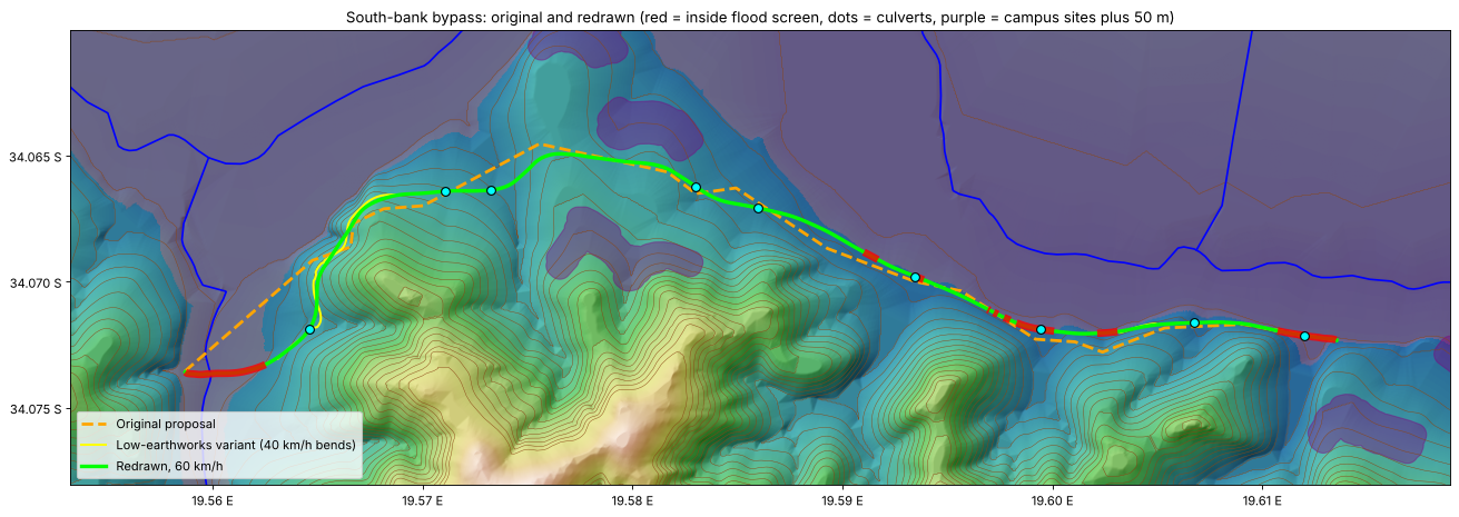
Orange: the first line of the bypass. Green: the new line for a 60 km/h road. Yellow: a version that follows the ground more closely. Red: where the new line runs inside the flood screen. Purple: campus sites, with 50 metres kept clear around them.
Who would decide
- Farm 39 is held by the national Minister of Land Reform and Rural Development in trust for residents [IC]. The Transformasie Komitee is the community’s mandated body for the land [MS]. Options 1, 2 and 5 are on Farm 39.
- Erf 595. Who holds most of Erf 595 has not been established [TBV]. Greyton’s histories say its founder left the land around the village to the plot owners as a commonage [TBV]. Whether Erf 595 is that commonage is still open (see Erf 595, Greyton). Options 3 and 4 are on Erf 595.
No one has been asked whether the campus could use any of this land.
What is still open
- Whether the land can be used at all. The Transformasie Komitee, the Department of Land Reform, Theewaterskloof Municipality and Greyton’s residents bodies have not been asked.
- Where the river really runs, above all near Option 4. The study moved the mapped river lines using the contours. A site visit would confirm or correct this.
- The height of the riverbed. Only four contour lines cross the river between Genadendal and Greyton. Between them, the study’s riverbed heights could be out by about 5 metres either way [MS]. Options 4 and 5 sit right at the 10 metre limit.
- The flood line. The study’s flood screen is a desk estimate. Only a flood line drawn by an engineer can show where it is safe to build.
- The ground itself. The study cannot see soil, rock, plants or old buildings. Earthships need ground that can be dug and packed against the walls.
- Roads. The map shows only the proposed bypass. The old dirt road to Option 5 is not on it, and the study has not checked its route.
- Fire. The map has no information on plants. The fire scores come from the shape of the land only.
- The candidate sites. Candidates A, B and C were found by the study’s own search. Nobody has visited them, and the same questions about land, river and ground apply to them as to the five proposed sites.
What happens next
- The study is tabled with the Valley of Grace Learning Campus at the DevForum’s November 2026 meeting.
- The Transformasie Komitee and the holders of Erf 595 are asked whether the campus could use any of the sites.
- If the DevForum goes further, someone visits the top two sites to check where the river runs and what the ground is like.
- A surveyor maps the chosen site in detail, and an engineer draws the flood line.
- The soil is tested to see whether it suits earthship building.
What the site might look like from the R406
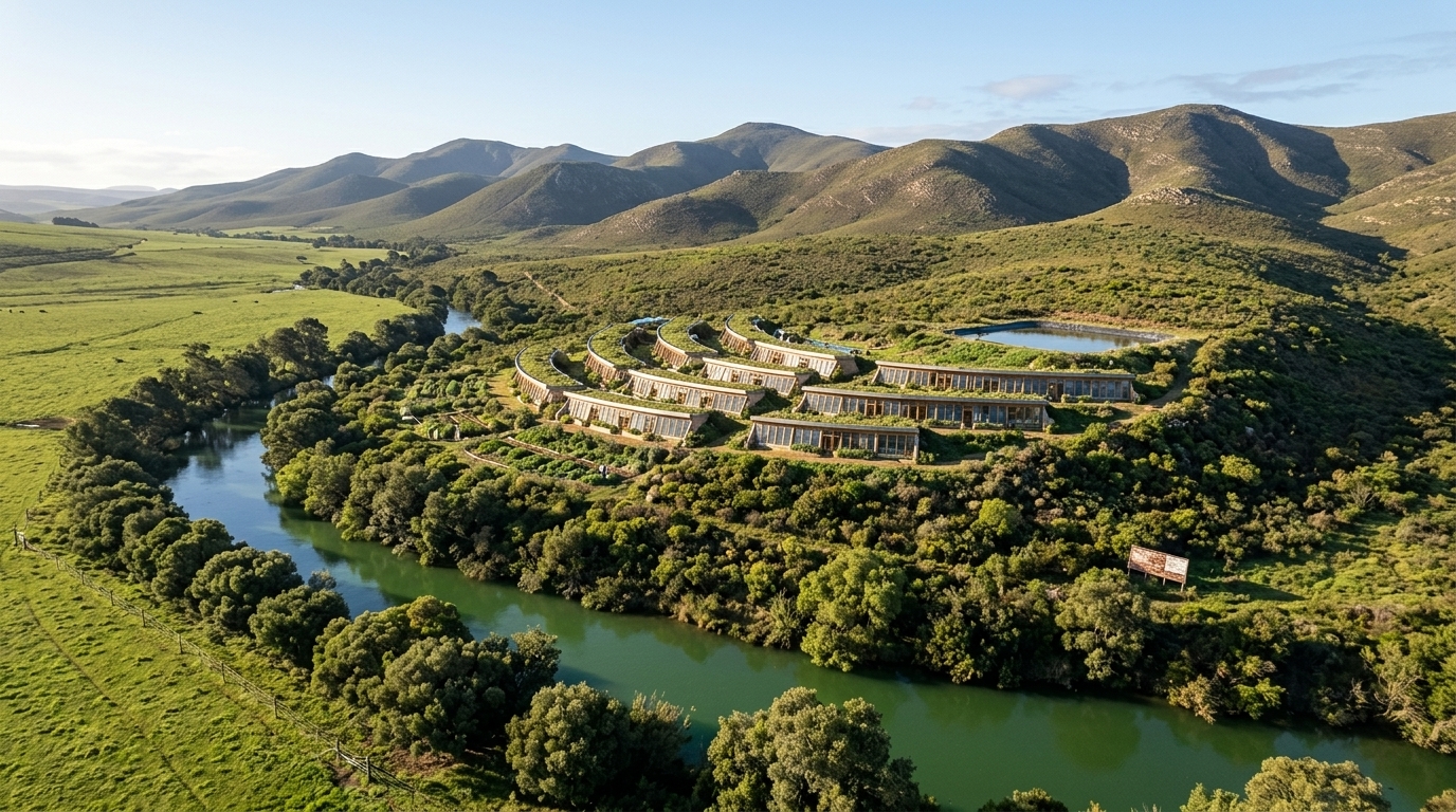
AI-generated image seen from the R406. Not to scale and merely a depiction — a more realistic image will be prepared in due course.
Have your say
If you know these sites, the river, the old road to Option 5, or how the land is used today, contact the moderators via How to Submit, or come to the November meeting.
Related
- Valley of Grace Learning Campus
- Restoring the River: Water Skills at the Learning Campus
- A South-Bank Bypass Road
- Community-Built Dams on the Baviaans and Gobos
- Farm 39
- Erf 595, Greyton
- Ideas for the Valley
References
- DevForum moderators. Google Earth map of the valley’s land. The study’s only data source. It holds the national contour lines from National Geo-spatial Information (20 metre lines, and 10 metre lines with 5 metre lines on flatter ground, from aerial photography of 2007, through the Western Cape Government Spatial Data Warehouse), the Surveyor-General boundaries of Farm 39 and Erf 595, the river lines, the possible dam sites and the proposed bypass.
- DevForum moderators. Learning Campus site study, phases 1 to 3 (November 2026). The full working report, with every measurement and assumption, held by the moderators.