For Theewaterskloof Municipality, the Department of Land Reform and Greyton's residents bodies to review
This page has not yet been checked by the bodies it names. Questions for them:
- For Theewaterskloof Municipality: who holds title to the Remainder of Erf 595, and to Erf 1723 and Erf 1724, and how is each zoned and used?
- For the Department of Agriculture, Land Reform and Rural Development: when, and why, did it buy Erf 1723?
- For the Greyton Ratepayers and Residents Organisation and the Greyton Conservation Society: do you hold any record of the commonage Vigne is said to have left to the plot owners, and of its terms?
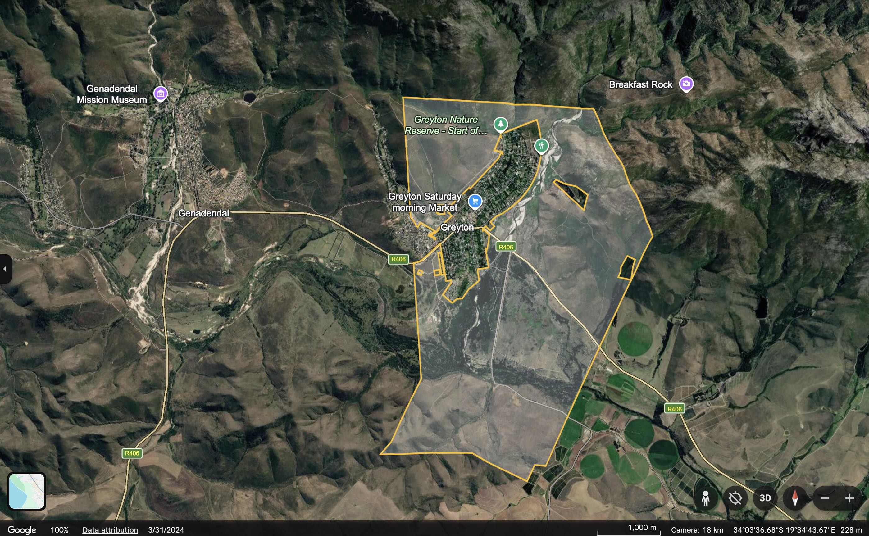
Erf 595 is a large property around Greyton and Heuwelkroon. The Surveyor-General records it as the Remainder of Erf 595 in the Greyton township, made up of seven separate parcels with a combined area of 1,404.89 hectares [IC]. A small part in Heuwelkroon is authorised for 333 homes [IC]. Most of the erf has no published use, and who holds and manages it outside the housing site has not been established [TBV].
Map: see this property on the DevForum’s Google Earth map of the valley’s land, which shows the Surveyor-General boundaries of all eight properties.
What the letters in square brackets mean
Facts on this page are followed by a tag that shows where they come from.
- [IC] Independently Corroborated. Confirmed by at least two sources that do not depend on each other, or by an official record such as a Surveyor-General record, an environmental authorisation or a municipal report.
- [MS] Mission-Sourced. Comes from one party’s own documents or statements, or from the DevForum’s own research and maps. It has not been checked against other sources.
- [TBV] To Be Verified. Seems likely, but nobody has confirmed it yet.
Sentences that begin with Inference are this page’s own reasoning. They are not facts.
At a glance
| Property in the Surveyor-General’s records | RE/595, Greyton township, Caledon registration division [IC] |
| Surveyor-General code | C01300110000059500000 [IC] |
| Area | 1,404.89 hectares in seven parcels [IC]; “approximately 1425 ha” in the 2022 environmental management programme [MS] |
| Held by | Not established. The municipality applied for the housing authorisation [IC]; the national Department bought Erf 1723, a portion of Erf 595 [TBV] |
| Authorised use | 333 homes on about 6 to 7 hectares in Heuwelkroon (10 July 2025) [IC] |
History
- Before Greyton. The land around the Gobos River was Hessequa grazing land, and was granted as the farm Weltevreden in 1793 [IC].
- 1846 to 1854. Herbert Vigne bought Weltevreden in 1846 and laid out Greyton, with the first plots sold in 1854 [IC]. Plot owners shared grazing on the commonage around the village [MS].
- The commonage. Greyton’s histories say Vigne left the land around the village to the plot owners as a commonage, and that it passed to Theewaterskloof Municipality in 2000 [TBV]. No will, deed or title condition has been found [TBV]. Inference: the Remainder of an erf in the Greyton township, surrounding the village in several parcels, fits the description of a village commonage. Whether Erf 595 is that commonage, in whole or in part, has not been confirmed.
- 1968 to 1974. Coloured families forced out of Greyton under the Group Areas Act were moved to Heuwelkroon, which the 2022 heritage study says was built around 1970 [TBV]. The housing site on Erf 595 lies in Heuwelkroon [IC].
- 1977. The Greyton Nature Reserve was proclaimed on the “mountain commonage” above the village [IC].
- 2000. Greyton became part of Theewaterskloof Municipality [IC].
- 2022. A national Department tender states that “the Remainder of Erf 1723 (Portion of Erf 595) was purchased by the Department of Rural Development”, with its zoning shown as “Undetermined Zone” [TBV]. A second tender covers Erf 1724, also a portion of Erf 595 [TBV]. Inference: parts of the original erf have been subdivided off, which is why the Surveyor-General records the Remainder.
- 2022 studies. The environmental management programme described “approximately 548 residential erven” for “low cost integrated housing” [MS]. The heritage study found “very little mitigation required” [MS]. The housing site was described as degraded, with alien trees and a deeply eroded tributary channel [IC].
- 2024. Heritage Western Cape approved the urban design on 18 July 2024 [IC]. GroundUp linked the relocation of Madiba Park households to this site [MS].
- 10 July 2025. The province authorised 333 homes, a mix of GAP and subsidy housing, for “beneficiaries on the municipal housing list for Greyton” [IC]. The authorisation does not name Madiba Park [IC].
- 2025 to 2026. The municipality’s capital programme listed the project, “Greyton Erf 595 (538)(Yield reduced)(393)”, with R10 million from the Human Settlement Grant [IC]. The budget “was removed with the February 2026 Adjustment Budget”, after R1,204,753 had been spent [IC].
- 2026. Ward 2’s Community Needs List puts the housing backlog, including “Madiba Park and backyard dwellers”, first, and says the municipality “must look at the possibility to use erf. 595, Greyton” [IC].
On the DevForum’s map
- The seven parcels lie around Greyton, from the mountain slopes north of the village to land south of it [MS].
- The Gobos dam-wall option drawn at the mouth of the kloof above Greyton (G3) falls inside Erf 595 [MS]. It is an option for the idea on Community-Built Dams on the Baviaans and Gobos, which the DevForum has not agreed.
- The DevForum’s map point marked “Sewerage Wetlands” falls inside Erf 595 [MS].
- Inference: outside the 6 to 7 hectare housing site, more than 99% of the erf has no use recorded in any source found.
What is still open
- Who holds title to the Remainder of Erf 595, and which body manages it.
- Whether it is the commonage Vigne is said to have left, and on what terms.
- How each part is zoned and used, and its condition (invasive plants, erosion, fire).
- How much of it lies inside the Greyton Nature Reserve, or is Greyton Shale Fynbos.
- Who the housing beneficiaries are, why the budget was removed, and when building will start.
- What the municipality earns from the erf, and what holding it costs.
- What the date on the Surveyor-General record (22 February 2024) marks.
Have your say
If you hold records of the commonage or of Erf 595, contact the moderators via How to Submit.
Related
- Greyton
- Heuwelkroon
- Madiba Park
- Madiba Park: Land Status and Basic Services
- Next Door, Different Rules
- History of Greyton
- Greyton’s Leiwater
- Theewaterskloof Spatial Development Framework
- All villages
References
- Chief Surveyor-General. Cadastral record for the Remainder of Erf 595, Greyton, shown on the DevForum’s Google Earth map of the valley’s land. The property, code, parcels and area.
- Western Cape DEADP. Environmental Authorisation, Integrated Housing Development on Erf 595, Heuwelkroon, Greyton (10 July 2025).
- Ohana Environmental Consulting. Environmental Management Programme, Erf 595 (May 2022).
- ACO Associates. Heritage Impact Assessment, Erf 595 (April 2022). Register entry: Heritage Impact Assessment, Erf 595, Greyton.
- Department of Agriculture, Land Reform and Rural Development. Tenders SSC WC Q11 and SSC WC Q12 (2022/23). Read only in part.
- Theewaterskloof Municipality. Section 71 and 52 reports, October 2025 and March 2026. The capital programme.
- Theewaterskloof Municipality. IDP 2022 to 2027, 2026 amendment, Appendix 1. The Ward 2 Community Needs List.
- GroundUp. Conditions in Greyton settlement worsen as land restitution process drags on (30 May 2024).
- History of Greyton, and the sources listed there.