A research record for the DevForum to review
This page records the challenges the valley has faced and where each stands in 2026. It is the first of two research runs. The DevForum has not adopted it, and the people and bodies it describes have not yet checked it. A second run, after DevForum review, will read these challenges as opportunities. This page proposes nothing.
Questions for reviewers:
- For the Genadendal Transformasie Komitee: does the page describe the Farm 39 process, and the Komitee’s part in it, correctly? Has the Communal Property Association been registered?
- For Theewaterskloof Municipality: who holds title to Erf 595 and its subdivisions, and how does Genadendal’s debt break down by service?
- For Madiba Park residents: do you accept how your statements are recorded here?
- For the Greyton Ratepayers and Residents Organisation: do you hold records of the commonage, the leiwater rights, or the removals to Heuwelkroon?
- For anyone: which [TBV] claims can you confirm, and from which documents?
The challenge that reaches furthest into daily life in Ward 2 in 2026 is land title. Twenty-eight years after the Transformation of Certain Rural Areas Act (TRANCRAA) came into force, the trust land of Farm 39, on which Genadendal, Bereaville, Voorstekraal, Boschmanskloof and Madiba Park stand, is still held by the national Minister, and no receiving body has been recognised [MS]. On the Greyton side, Erf 595 measures 1,404.89 hectares in the Surveyor-General’s records [IC], and only a small part of it has a published use: 333 homes authorised in July 2025 [IC]. This page traces these and the valley’s other challenges from the first people to 2026, records what the DevForum has heard so far, and arranges the 2026 evidence for the second research run.
What the letters in square brackets mean
Facts on this page are followed by a tag that shows where they come from.
- [IC] Independently Corroborated. Confirmed by at least two sources that do not depend on each other, or by an official record such as a law, court order, gazette or government report.
- [MS] Mission-Sourced. Comes from one party’s own documents or statements, or from the DevForum’s own research and records. It has not been checked against other sources.
- [TBV] To Be Verified. Seems likely, but nobody has confirmed it yet.
Sentences that begin with Inference are this page’s own reasoning. They are not facts.
How to read this page
- Sections 1 to 3 tell where the challenges came from and where they stand.
- Section 4 arranges the 2026 evidence under the headings Ecological ceilings, Social floor and Provisioning systems, for the second run’s Metabolic Study.
- Sections 5 to 7 describe how the valley is seen, the questions still open, and who must be asked.
- Every party is described only through what it has said or done. Where Greyton and Genadendal interests conflict, each side’s statements are given in its own words and tagged [MS].
- TRANCRAA is a land reform law. In 2014 the Land Claims Court held that it does not deal with land restitution [IC]. Where a source calls it restitution, this page says so.
The official picture in short
Government documents describe the valley through poverty, teenage pregnancy, substance abuse and crime. This section records what could be confirmed.
Every figure below is for the whole of Theewaterskloof Municipality, which has fourteen wards [IC]. Wards can be explored using this link. No official source reached gives these figures for Ward 2 or for any single settlement.
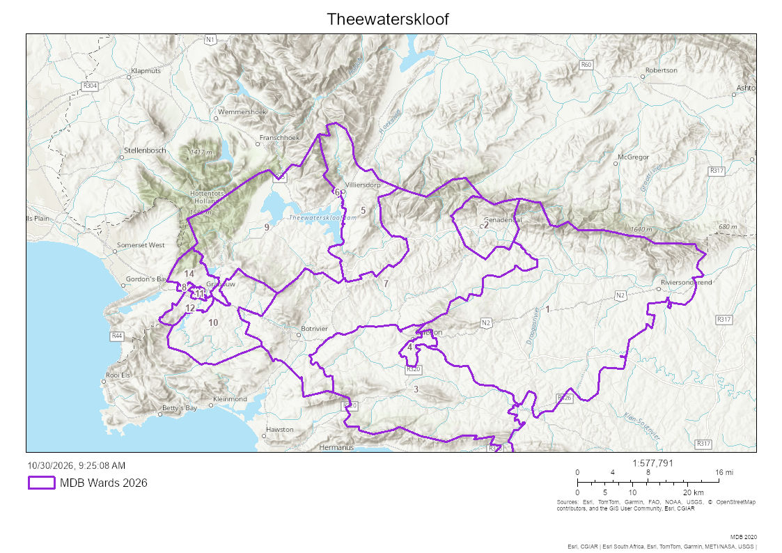
- Population. The Provincial Treasury’s 2024 Socio-economic Profile gives 128,320 people in 33,088 households in 2024, from Stats SA’s mid-year estimates [IC]. The 2026 IDP amendment gives 124,050 people in 35,990 households in 2021 [IC]. Sources citing Census 2022 give 139,563 people in 36,239 households [TBV]. The latest settlement counts found are from Census 2011: Genadendal 5,663 people and Greyton 2,780 [TBV]. From our own informal counts, we believe these numbers are significantly lower than the actual number of people in the valley, so we generally refer to 30,000 residents.
- Poverty. In 2023, 69.0% of the municipality’s people lived below the upper-bound poverty line of R1,684 per person per month (2024 value) [IC]. The IDP gives 53.33% for 2021, measured against a line of R1,227 in 2019 prices [IC]. The two figures use different line values and should not be read as a trend. The number of indigent households receiving free basic services rose to 6,396 in 2023 [IC]. Earnings for farm labour stayed between R3,200 and R6,400 a month in 2022 and 2023 [IC].
- Ratings of need. The 2026 IDP amendment repeats a 2004 rating: Greyton has “low human needs and low development potential”, and Genadendal “medium human needs and low development potential” [IC]. The IDP records that residents and the municipality disagree with Greyton’s rating [IC]. The 2023 draft spatial plan, as quoted by Ranyaka, says a “high level of poverty exists” in Genadendal, Voorstekraal, Bereaville, Heuwelkroon and Boschmanskloof [MS].
- Work. Unemployment (narrow definition) was 12.2% in 2023 [IC], down from 13.9% in 2021 in the IDP [IC].
- Teenage pregnancy. In 2023/24, 15.3% of deliveries in the municipality were to women aged 10 to 19, which was 263 births, up from 14.9% the year before [IC]. The IDP gives 16.2% for 2021/22 [IC]. The IDP’s summary table labels that figure “U18” and its text says “under 20 years” [IC].
- Crime. Reported cases in the municipality, from the 2024 profile [IC]:
| Crime | 2022/23 | 2023/24 | Rate per 100,000, 2023/24 |
|---|---|---|---|
| Murder | 77 | 57 | 44 |
| Sexual offences | 116 | 87 | 68 |
| Drug-related crime | 1,152 | 1,213 | Not given |
| Residential burglary | 633 | 659 | 513 |
| Common assault | 682 | 649 | Not given |
| Driving under the influence | 273 | 193 | Not given |
The profile’s summary page gives 59 murders and 84 sexual offences for 2023/24, which differs from its own table [IC]. The IDP gives the 2021/22 figures: 59 murders, 87 sexual offences, 923 drug-related crimes, 624 residential burglaries [IC].
- Housing and services. In 2024, 80.1% of households lived in formal housing and 19.6% in informal dwellings, against 13.7% informal across the Overberg District [IC]. 96.8% had piped water, 93.2% electricity for lighting, 83.9% a flush or chemical toilet, and 75.4% weekly refuse removal [IC].
- Health and learning. The municipality has six fixed clinics, 13 mobile or satellite clinics and one district hospital, in Caledon [IC]. It had 27 severely malnourished children under five in 2023/24, the most in the district [IC]. The matric pass rate was 87.1% in 2023, and only 71.6% of learners stayed from Grade 10 to Grade 12 [IC].
- Gender-based violence and substance abuse. No municipal or settlement figure for gender-based violence was found. Ward 2’s needs list asks for a safe house for abused women and children [IC], and Ward 4’s asks for help with gender-based violence and substance abuse [IC].
- Where to get help. SAPS Crime Stop: 08600 10111. Gender-Based Violence Command Centre: 0800 428 428 [TBV].
Residents also scored the valley themselves. In the 2024 Ranyaka sessions, seven groups of about eight to ten people gave the valley an overall score of 48% [MS]. Social cohesion scored highest, and well-being (“healthy, educated and active”) lowest [MS].
1. The historical record
This section follows the eras of History of the Valley. For each era it gives the challenges that arose and what produced them, who bore them, what people did, and what was lost or carried through.
The first people (before 1652)
- Challenges. People lived in this area more than 200,000 years ago [IC]. The Soaqua, the San of this part of the Cape, lived by hunting and gathering [IC]. When Khoekhoe herders arrived about 2,000 years ago, the Soaqua moved higher into the mountains [IC].
- Who. By the 1600s the Chainoqua and the Hessequa were the two main Khoekhoe peoples of the Overberg [IC]. Some Chainoqua kraals stood near where Genadendal is today [IC].
- How land was held. Land was held by the group as a whole, and nobody could divide it for themselves [IC]. Herders moved with the seasons, so the land looked empty when they were away [IC].
- What carried through. Names such as Gobos [TBV]. Rock art survives in the mountains [IC]. Its locations are not given on this site.
Contact with the Dutch (1652 to 1737)
- Challenges and causes. The Chainoqua first met the Dutch East India Company (VOC) in 1657 [IC]. For about fifty years they and the Hessequa were the main suppliers of cattle to the Cape [IC]. In 1669 Dutch travellers found rich grazing at the Huis River, where Greyton stands, and settlers took land that looked empty as free to take [IC]. Smallpox in 1713 killed many Khoekhoe, and more settlers moved onto their land [IC]. By 1727 the VOC was farming timber and cattle between present-day Greyton and Riviersonderend [IC]. See Loan Farms and Quitrent.
- Who. Khoekhoe herding communities of the Overberg [IC].
- Response. Greyton sources say the Hessequa leader Stoffel Koekson moved his people to Boschmanskloof [TBV].
- What was lost. Herds, grazing and people, through trade, disease and the spread of farms [IC]. Independent Khoekhoe kraals were still recorded near Genadendal in 1803 [IC].
Georg Schmidt at Baviaanskloof (1737 to 1744)
- Challenges and causes. Schmidt settled at Baviaanskloof on 23 April 1738 [IC]. Local Dutch Reformed ministers objected that he had no right to baptise, and farmers were unhappy to lose cheap Khoekhoe labour [IC]. He left in 1744 and was never allowed back [IC].
- What carried through. Teaching under the pear tree, a water furrow and gardens [IC]. Five baptised converts, among them Vehettge Tikkuie, known as Magdalena [MS].
Magdalena and the pear tree (1744 to 1792)
- Challenges. For 48 years there was no missionary at Baviaanskloof [IC].
- Response. Magdalena kept the small congregation together and read to them from the Dutch New Testament Schmidt had left her [IC]. She kept it wrapped in sheepskin [MS].
- What carried through. The congregation, and the place. She died on 3 January 1800 [IC].
The mission grows (1792 to 1838)
- Labour, debt and the contest over children. The missionaries’ diaries of the 1790s show farmers keeping back children who went to the mission school “against their parents’ will” [MS]. Workers came home from the harvest owing the farmers as much as they had earned [MS]. See From Farm to Classroom.
- The Caledon Code of 1809. It required every Khoekhoe person to have a fixed, registered place of abode and to carry a pass, and anyone without one could be treated as a vagrant [IC]. See Caledon Code.
- The apprenticeship law of 1812. It let a colonist who had kept a Khoekhoe child on his farm for its first eight years keep the child in unpaid service for ten more [IC]. One historian counts at least 2,295 children apprenticed between 1812 and 1823 in the districts he studied [TBV].
- Ordinance 50 of 1828. It repealed these laws, removed the pass requirement, let people choose their employers and own land, and gave free people of colour equality before the law [IC].
- Who. Khoekhoe families on the farms and at the mission [IC].
- Response. The mission became one of the few places where Khoekhoe people could live without working for a farmer [TBV]. In 1794 the missionaries used the government’s orders to stop a farmer taking two girls from their mother [MS].
- What carried through. A forge and water mill (1797), Genadendal knives sold across the Cape, a school from 1793 that still runs today as L.R. Schmidt Primary [MS]. In 1813 a surveyor mapped the mission’s boundary, and residents were given no proof that they owned their land [MS].
Emancipation and the busy years (1834 to 1860s)
- Challenges and causes. Slavery ended in law in 1834, and people were fully free on 1 December 1838 [IC]. The Masters and Servants Ordinance of 1841 again made breaking a labour contract a crime, and was replaced by Act 15 of 1856 [IC]. Their effect in the valley has not been traced [TBV].
- Who. Freed people arriving at the mission. Genadendal grew from 1,446 people in 1837 to 2,187 in 1840 [MS].
- The land grant of 1858. In November 1857 the surveyor J. Kuys measured the mission land at 5,644 morgen and 289 square roods [MS]. In 1858 it was granted to the Moravian Church “for the use of and in trust for such persons as may from time to time be lawfully resident at the institution of Genadendal” [MS].
- Response, in residents’ terms. Balie’s history says many residents rejected the grant because the church’s superintendent was the only trustee, and no resident sat beside him [MS]. It says they held that the land had belonged to their Khoi ancestors [MS].
- What carried through. South Africa’s first teachers’ training college opened in 1838 [IC]. The press printed De Bode van Genadendal from 1859 [IC]. The brass band dates from 1856 [MS].
Greyton is founded (1793 to 1910)
- Challenges and causes. Hessequa grazing land on the Gobos River was granted to Marthinus Theunissen as the farm Weltevreden in 1793 [IC]. Herbert Vigne bought it in 1846 and laid out Greyton, with the first plots sold in 1854 [IC].
- What the plots held. Each plot came with a title deed, a water right and grazing rights, and plots were sold to buyers of any race [TBV]. Plot owners shared grazing on the commonage around the village [MS]. The leiwater furrows have carried Gobos water to plots with a water right since 1854 [MS]. See Greyton’s Leiwater.
- The commonage. Greyton’s histories say Vigne left the land around the village to the plot owners as a commonage [TBV]. A formal record of his will or deed of gift, recognised by the state, has not yet been sourced [TBV].
- What carried through. Greyton had 276 residents in 1891 [IC] and became a municipality in 1910 [IC].
Hard years: land, work and law (1860s to 1950)
- The crafts decline. Cheap factory-made goods arriving by steamship undercut Genadendal’s knives, furniture and other crafts, and many people left to find work in towns and on farms [TBV]. Balie’s history says Sheffield knives were sold at the Cape with the Genadendal mark, and the last of Genadendal’s knife-makers died in 1880 [MS]. From 1877 the mission tried castor oil, silkworms and buchu for export [MS].
- The water sources. In 1899 the Moravian Church bought the mountain farm Langgezocht (Farm 32) to protect Genadendal’s water sources [MS].
- The Act of 1909. The Mission Stations and Communal Reserves Act (Act 29 of 1909) placed mission land under management boards [IC]. Residents kept the right to live on the land, but could not own it [IC]. Balie’s history says the Act gave the mission title to its church, school and houses, reserved the rest for registered occupiers, and set up a board of six elected and three nominated members [MS]. It says many residents left the Moravian Church over the Act [MS].
- The land cases. Balie’s history records a case over land ownership brought against the mission in the Supreme Court at the end of the 1800s, and another brought in 1924 by a group of residents known as the Magermans [MS]. What either court decided has not been found [TBV].
- Who governed. In 1924 a secular board of management replaced the missionaries [IC].
- The college closes, 1926. The government closed the teachers’ college, arguing that coloured people did not need higher education because they were suited to work on farms [IC]. It had trained 236 teachers [MS].
- The Glebe Lands, 1927. Title to the core mission areas of Genadendal and Bereaville, known as the Glebe Lands, was granted free of charge to the Moravian Church in 1927 [IC]. The Ward 2 Forum’s 2017 series describes them as “nine portions of land” of 68 hectares [MS], and the consultants’ 2010 report gives 70.7795 hectares [MS]. They were cut out of the mission land before the state’s 1952 deed of grant for Farm 39, so the Deeds Office record of the farm does not include them [IC]. They sit outside the TRANCRAA process [IC]. In the Surveyor-General’s records the Glebe Land is Farm 827, Caledon, named “GLEBE LAND”, 61.11 hectares [IC]. The Deeds Office report records Portions 3 to 7 of Farm 39, about 2.34 hectares, as consolidated into Farm 827 [IC]. The parcel covers Genadendal’s mission core, and where the Bereaville portions of the 1927 grant are recorded is still open [TBV]. See Farm 827: The Glebe Land.
- What carried through. A high school opened in the old college building in 1938, and later became Emil Weder Secondary [MS]. Balie’s history says Genadendal stayed an undeveloped village of about 5,000 people under a series of government departments from 1926 to 1997 [MS].
Apartheid (1950 to 1994)
- The Group Areas removals. Under the Group Areas Act of 1950, coloured families in Greyton, many of whom owned plots and small farms, were forced to sell and leave [IC]. Most were moved to Heuwelkroon [IC]. The 2022 heritage study says some went to Genadendal [TBV].
- When. Sources differ. Some Greyton histories say the 1950s [TBV]. An essay in Herri gives 1968 to 1974 [MS], and the 2022 heritage study says Heuwelkroon was built in 1970 [TBV]. The two later sources agree with each other.
- In the words of those affected. The Herri essay says that before the removals Greyton’s residents “lived together irrespective of ‘race’”, and that afterwards “a community of subsistence farmers who owned their own farms were overnight reduced to having to work as gardeners and domestics for white people” [MS].
- In Genadendal. Balie’s history says fear of removal spread to Genadendal, and many residents stopped maintaining their houses [MS]. Members of the Teachers’ League met in the parsonage loft to oppose apartheid, and one was placed under house arrest in 1962 [MS].
- The water mill. In the 1950s co-operative laws forced farmers to send their wheat to licensed co-operatives, and the water mill closed [MS]. It was restored in 1992 [MS].
- The mountain. On 13 May 1977 the Greyton Nature Reserve, about 2,200 hectares, was proclaimed on the mountain commonage [IC].
- Act 9 of 1987. The Rural Areas Act 9 of 1987 took over the former mission areas, with most of the land held by the state in trust for residents [IC]. Genadendal was added in 1989 [IC].
- What carried through. The Mission Museum opened in the 1838 college building in 1987 [MS].
Democracy and the land question (1994 to 2011)
- Local government. In the mid-1990s transitional councils replaced Greyton’s white council and the Heuwelkroon management committee [IC]. In December 2000 the valley became part of Theewaterskloof Municipality [IC].
- TRANCRAA. The Act came into force on 2 November 1998 [IC]. Trust land inside a township passes to the municipality, and the Remainder may go to the municipality, a Communal Property Association (CPA) or another body the Minister approves [IC].
- The process on Farm 39. The municipality began it in 2002 through consultants it appointed [IC]. Residents elected the Transformasie Komitee on 9 November 2004 [IC]. The Komitee rejected the 2005 list of residents as incomplete [IC]. On 31 January 2007 it applied to the High Court (case 926/07) to review the municipality’s actions, including the “sale and transfer of trust immovable property” [IC]. The settlement became an order of court on 22 October 2008, with “an immediate moratorium on the sale of Trust Land” [IC]. The 18-month transitional period began on 8 July 2009 and ended in January 2011 without a transfer [IC]. Full story: TRANCRAA and Farm 39: The Land Transfer Process.
- The printing works. The Genadendal printing works closed in 2003 after more than 170 years [MS]. Balie’s history says the presses moved to Cape Town in 2002 to 2003 [MS].
Recent years (2011 to 2026)
- 2011. Greyton residents started Greyton Transition Town in response to rising fuel and food costs [MS].
- 2014. The Land Claims Court struck the Komitee’s application from the roll for lack of jurisdiction [IC].
- 2016. The municipality wrote that “a hostile environment has over the years developed between the TWK and the Transformation Committee” [MS], and asked the Minister to transfer the land to it [MS].
- 2017. The Ward 2 Forum published Farm 39 Transformation: The Lost 18 Years [IC]. The municipality named Madiba Park as a possible site for families displaced in Bereaville [MS].
- Madiba Park, 2019. Chemical toilets were removed on 13 January and the water was cut off on 14 January, and residents protested [IC]. GroundUp reported “about 100 shacks on the land, housing about 300 people” [MS]. The municipality promised four flush toilets, a septic tank, and serviced plots elsewhere within 18 months [MS].
- The 2019 ruling. The High Court let two Genadendal residents defend claims for unpaid municipal accounts on the ground that their land falls under TRANCRAA, and left the question for trial [IC].
- The fire of December 2019. About 5,950 hectares burned on the mountain slopes above Greyton [IC]. A firefighter interviewed on a podcast described the fire as burning 16,500 hectares, including parts of McGregor, Genadendal and Voorstekraal [MS]. The two figures may describe different areas [TBV].
- 2020. Residents halted a proposed R100 sale of an eight-hectare parcel in Greyton [MS]. Small-scale and commercial farmers set up a community feeding scheme during the lockdown [MS].
- 2022 to 2023. The municipality budgeted R1.6 million to electrify Madiba Park, then cut the project in the February 2023 adjustment budget, with R73,135 spent [IC].
- 2024. The province intervened in the municipality under section 139 of the Constitution on 11 November 2024 [IC].
- 2025. The province authorised 333 homes on Erf 595 on 10 July 2025 [IC]. The Financial Recovery Plan was approved on 7 October 2025 [IC]. The Komitee aligned with AfriForum and the Kaapse Forum, and began setting up a CPA to receive the land [MS].
- 2026. The municipality signed a new repayment agreement with Eskom in March 2026 [IC]. Council amended the IDP on 28 May 2026 [IC]. The DevForum met for the first time on 16 September 2026 [MS]. Local government elections are set for 4 November 2026 [IC].
2. The DevForum’s own record
The inaugural meeting, 16 September 2026
The signed minutes are the source for every row [MS]. Sectors are named as the minutes record them. See Inaugural Meeting, 16 September 2026.
| Challenge raised | What was said | Sector | Deeper condition (Section 1) |
|---|---|---|---|
| Community gardens lying fallow | ”The number of community gardens that are currently lying fallow”, and “the need to better utilise existing community assets” | Agriculture discussion | Land and tenure; water |
| No working tourism office | ”The lack of a functioning tourism office in the ward”; Adventure Hub Greyton acts as an information point informally | Tourism operators | Governance; work and money |
| Tourism transport permits | ”Concerns regarding tourism transport permits and associated regulatory delays” | Tourism operators | Governance |
| Building plans, sewage and maintenance | ”Building-plan approval processes, infrastructure maintenance, sewage, municipal processes, and the gap between planning and implementation” | Several sectors | Housing and services; land and tenure |
| Skills on farms and in tourism | Mechanics, machine operators, computer, hospitality and communication skills | Commercial farmers and tourism | Learning; work and money |
| Host farms for Elsenburg courses | The Department funds NQF 3 and 4 qualifications; “applicants must secure a host farm for the practical component” | Western Cape Department of Agriculture | Learning; land and tenure |
| Life skills and violence prevention | ”Life skills, communication, respect and violence prevention” | Several sectors | Learning |
| Involving communities from the start | Affected communities “should be involved from the beginning of proposals” | Genadendal participants and the Transformasie Komitee | Governance and representation |
| Water and mentorship | ”Available water resources”, “community land and associated water rights”, and “mentorship between commercial and emerging farmers” | Farmers and the Department of Agriculture | Water; land and tenure |
| Money spent outside the ward | To “develop local supply chains and retain more economic activity and expenditure within the ward” | Business | Work and money |
| TRANCRAA and Farm 39 | ”The longstanding nature of the process” and “the ability of the community to utilise its land and associated resources effectively”; about 4,800 hectares | Genadendal participants and the Transformasie Komitee | Land and tenure |
| Ward governance | ”Municipal coalition dynamics and their effect on ward-level service delivery” | Several sectors | Governance |
The minutes give Farm 39 as about 4,800 hectares [MS]. The Surveyor-General’s records give 4,498.09 hectares, and this site uses that figure [IC]. The DevForum recorded that TRANCRAA has other platforms and that it would avoid duplicating them [MS].
The Ward 2 IDP public meeting, 27 November 2025
The municipality held one IDP meeting for Ward 2, at the Moravian Hall in Greyton, on 27 November 2025 [IC]. Appendix 1 of the 2026 IDP amendment holds two records for the ward: the Community Needs List, and a summary of issues raised in Greyton and Genadendal [IC]. Inference: the summary records that meeting, since it was the only Ward 2 meeting held for this amendment.
The Community Needs List for Ward 2, in the IDP’s own order [IC]:
- “Addressing the housing backlog (includes Madiba Park and backyard dwellers)”, with the note that the municipality “must look at the possibility to use erf. 595, Greyton for housing projects/serviced erven”.
- Services for those houses.
- Generators for the water and sewer plants and pump stations.
- Service delivery security for water, sewerage and roads.
- Mast lighting, and turning the old Heuwelkroon play park into a play park for children.
- Upgrading the Gobos sports field: power supply, toilets, and two new fields.
- Voorstekraal: extending the sewer lines, which form a partial network, to reduce suction tanker use.
- Reducing the risk of flooding in Ward 2.
- Repairing and upgrading the Boschmanskloof and Park Street bridges after flood damage.
- Rehabilitating gravel roads.
- Upgrading Church Street and Long Street in Bereaville.
- A safe house for abused women and children, with a recreation centre for Ward 2.
- Job creation, especially for the youth of Ward 2.
The IDP’s ward priorities table also lists netball fields in Genadendal and sports fields in Bereaville and Voorstekraal as needing upgrades [IC]. Against every Ward 2 sports item it says “subject to availability of funding”, and it refers the safe house to the Department of Social Development and outside funders [IC].
Issues raised in Greyton and Genadendal, as the IDP summarises them [IC]:
| Issue | What residents asked |
|---|---|
| Accountability | Whether consequence management has been applied for past financial mismanagement, and whether implicated officials are still employed |
| Staff | Merit-based appointments, vetting and skills checks |
| Civic partnerships | How civic organisations can work with the municipality |
| Baboons | Continued support for baboon monitors |
| Community contributions | A record of work residents do themselves, such as fire breaks, pothole repairs and baboon monitoring |
| Bonuses | Whether bonuses will be paid during the recovery |
| Tariffs | When tariff proposals will be public, and a chance for ratepayers to comment |
| Cross-subsidy | What share ratepayers pay to cover non-payment |
| Recovery updates | Monthly updates on the Recovery Plan, and a standing item on Ward Committee agendas |
| Water | Storage, availability, quality, and capacity for new development; officials to attend the leiwater meeting |
| Sewer tanker service | Computerised billing, and billing by the date of service |
| Genadendal revenue | ”Who is leading engagement with Genadendal residents on rates, taxes, and service fees” |
| Farm 39 | ”Progress and status of discussions related to Farm 39” |
| Genadendal and outlying areas | ”While the community acknowledged low revenue levels in Genadendal”, what plans exist to improve services there |
| Town manager | No designated Town Manager for Greyton and Ward 2, and the need for a permanent appointment |
The Ranyaka community sessions, 2024
Ranyaka Community Transformation held sessions across the valley from March to June 2024, with between 50 and 89 people at each [MS]. Stakeholders named these challenges [MS]:
- School safety needs attention, and the existing sports fields are unsafe.
- There are not enough counselling services for children.
- Health facilities are not sufficient.
- Enterprises need help with product development, and job creation needs attention.
The report notes that “there is little scope for the growth of businesses that serve only this area” [MS]. These connect to housing and services, work and money, and learning.
3. Three deep reports
3a. TRANCRAA and Farm 39, to October 2026
This updates TRANCRAA and Farm 39: The Land Transfer Process.
Where it stands. The Remainder of Farm 39, about 4,430 hectares outside the four township areas, is held in trust by the national Minister [IC]. No entity has been recognised [MS]. The 2008 order has not been set aside as far as the public record shows [TBV]. A Komitee office-bearer told GroundUp in 2024 that the community had set up a CPA and was waiting for the Department to finalise it [MS]. The Department’s spokesperson said “certain issues” were still outstanding [MS]. No record of a CPA registration was found [TBV].
Who cannot get title, credit, approval or services. No resident of the Remainder can hold title to land there until a transfer happens [MS]. Inference: without title, land cannot be offered as security for a bank loan. Residents raised building-plan approvals and sewage at the DevForum’s first meeting [MS]. In 2024 the municipality said it could not provide full services at Madiba Park because “the settlement is not on municipal land” [MS]. It had agreed with the Komitee to put five toilets and water tanks on the settlement’s edge [MS], and GroundUp found one toilet working [TBV].
Rates and the municipality’s debt. The Financial Recovery Plan says “Genadendal is particularly challenging as services are rendered and billed, but the community feels that the land does not belong to the municipality and that they therefore have no obligation to pay for said services” [IC]. In 2016 the municipality listed “the Rates boycott and the poor collection rate in Genadendal” as the first issue to resolve [MS]. The municipality’s own quarterly reports show Genadendal’s share of debt rising [IC]:
| Date | Genadendal debtors | Share of all debtors |
|---|---|---|
| 28 February 2025 (Recovery Plan) | Not given | About 20% |
| 31 October 2025 | R97,783,258 | 23.0% |
| 31 January 2026 | R103,966,817 | 23.2% |
| 31 March 2026 | R104,916,378 | 23.8% |
| 31 May 2026 | R108,357,195 | 23.7% |
Greyton’s municipal-supply area stood at R7,981,241 (1.75%) in May 2026 [IC]. Across the municipality, Eskom-supplied areas, where meters cannot be blocked, held 86% of all debt [IC]. The 2019 High Court ruling leaves open, for trial, whether residents of TRANCRAA land can be held liable for municipal accounts [IC].
The rule against investing on land the municipality does not own. The 2019 Spatial Development Framework states: “In terms of applicable municipal legislation, TWKM is not allowed to invest in infrastructure, where the Municipality is not the owner of the land” [IC]. The 2023 draft says “the tenure transformation process should be concluded before the TWKM may invest in engineering infrastructure within the settlements” [MS]. On Madiba Park the rule shows in the record: electrification budgeted at R1.6 million and cut in 2023 [IC], and the municipality’s two letters to the national Minister asking permission for interim services, which the DA said went unanswered [MS]. No figure was found for the value of infrastructure not built on Farm 39 since 2000 [TBV]. In its 2016 letter to the Department, the municipality named three issues to settle in the meantime: “The Rates boycott and the poor collection rate in Genadendal”, “The Waste Water treatment pipeline from Greyton to the Genadendal Waste Water Treatment Works”, and “Various issues relating to Town Planning and Building Control” [MS]. It wrote that the delays were “having a serious negative impact on the sustainability of the Municipality” [MS].
The properties said in 2017 to have been sold. The Komitee’s 2007 application objected to the “sale and transfer of trust immovable property” [IC]. The Ward 2 Forum’s 2017 series says over 200 residential properties on Farm 39 had been sold and transferred “with the knowledge and assistance of TWKM”, and that the consultants’ land rights report does not record them [MS].
The Deeds Office search report attached to the 2008 court order (Annexure GT1) is the fullest record found of what has been taken off the farm [IC]. It shows:
- The state holds Farm 39 under Deed of Grant G19/1952, dated 6 February 1952, at 5,572 morgen and 261 square roods, or 4,772.97 hectares [IC].
- Portions 1 and 2 of the farm became Erf 1555 (Gr130/1953) and Erf 68 (T47138/1984) [IC]. Portions 3 to 7, about 2.3 hectares together, were consolidated into Farm 827 [IC].
- Eight erven totalling 206.2451 hectares carry title deeds, and a further 134.994 hectares of surveyed erven are unregistered [IC]. Handwritten notes on the report name the “Gemeenskap van Genadendal” against most of the registered erven [MS].
- The registered remainder of Farm 39 on 25 April 2007 was 4,566.72 hectares, and the unregistered remainder 4,431.73 hectares [IC].
The consultants’ 2010 report puts the land in the process as the Remainder of Farm 39 (G19/1952, 4,614.56 hectares) and Erf 387 (T75345/95, 26.89 hectares) [MS]. The two sources disagree on Erf 1353: the 2017 series says the municipality owns it (T13058/1996) [MS], and the consultants’ lawyers say it was transferred to a private owner [MS]. What has happened to the 200 properties since 2017, and whether those transfers are valid, was not found [TBV].
Garden plots and leases. The consultants’ lawyers concluded in 2010 that users of the garden plots (tuin persele) hold registerable use rights, that ownership stays with the municipality, and that the “grondbriewe” the housing department issued for the plots were not in accordance with the law [MS]. They found that the farm leases on the Remainder had expired with no record of renewal, and the consultants could not verify the lease records [MS]. The 2005 and 2010 lease surveys do not match each other [MS].
Who counts as a resident. TRANCRAA counts anyone who ordinarily lived in the area on 2 November 1998, or was liable for rates there on that date [IC]. In July 2010 the municipality, the Department and the consultants decided that updating the residents list was “not further required” [IC]. The consultants wrote that an updated list “will have no material impact on the Transformation Process” [MS]. The Ward 2 Forum’s 2017 series says that people who moved in after the qualifying date, “who are considered by a majority of the Transformation Committee members to be in good standing, may be offered the opportunity to be considered as legitimate beneficiaries” [MS]. No later decision on this was found [TBV].
What other TRANCRAA areas show.
- Parliament was told in October 2024 that 603,000 of about 1.4 million hectares had been transferred, and that staff shortages, a lack of municipal co-operation and “disputes within communities about the land to be transferred” were the main obstacles [IC].
- Haarlem, Mamre and most of Ebenhaeser were transferred in 2020/21 [IC]. Enon/Bersheba went to the Witrivier CPA (8,314 hectares) [IC]. In August 2025 the Minister handed over title deeds to Namakwa bodies including the Pella, Concordia, Leliefontein, Steinkopf and Komaggas areas [IC].
- Every transfer found came more than twenty years after the Act [IC].
- In October 2024, 82% of South Africa’s 1,742 registered CPAs were not complying with the law that governs them [IC]. The Department’s 2024/25 CPA report says CPAs “are institutionally complex” and hold land for communities “fractured by the history of dispossession” [IC].
- Research in Namaqualand found that new tenure rights stay “vulnerable if isolated from training, finance and integrated development initiatives” [TBV].
- How Mamre, Haarlem, Ebenhaeser and Enon/Bersheba have fared since transfer was not found [TBV].
Statements by each side on Madiba Park. Each is that party’s own account.
- A Madiba Park resident, 2024: “When it comes near to the time, nothing happens, we protest and then they promise the same thing” [MS].
- The Komitee’s treasurer, 2019: “We want [the occupiers] off our land, onto municipal land” [MS]. GroundUp reported that the Komitee wanted room for “about 70 coloured families with a history of living in Greyton and nearby Genadendal” [MS].
- The Komitee’s treasurer, 2024: “We don’t want to evict people, we want to relocate them” [MS].
- Theewaterskloof Municipality, 2024: “most of Genadendal and Greyton land is under the flood line” [MS].
- An ANC member of the provincial legislature, 2019: “This site does not belong to the municipality yet they settled people here” [MS].
- No public statement on Madiba Park by a Greyton or Heuwelkroon residents body was found.
GroundUp called the process a “land restitution process” [MS]. TRANCRAA is a land reform law, separate from restitution [IC].
3b. Erf 595
Size. 1,404.89 hectares in the Surveyor-General’s records [IC]. The 2022 Environmental Management Programme says “approximately 1425 ha” [MS].
Owner and manager. The environmental authorisation was granted to Theewaterskloof Municipality as the applicant [IC]. It does not say who holds title. A 2022 national Department tender states that “the Remainder of Erf 1723 (Portion of Erf 595) was purchased by the Department of Rural Development”, and seeks a consultant to subdivide and rezone it from “Undetermined Zone” [TBV]. A second tender covers Erf 1724, also a portion of Erf 595 [TBV]. Only parts of the tenders were read. Inference: parts of the original erf have been subdivided, and at least one part may be held by the national Department. Who manages the land outside the housing site was not found [TBV].
Is it the Greyton commonage? Greyton’s histories say Vigne left the land around the village to the plot owners as a commonage, and that it passed to Theewaterskloof Municipality in 2000 [TBV]. No will, deed or title condition has been found [TBV]. No source reached says whether Erf 595 is that commonage, in whole or in part. The nature reserve was proclaimed in 1977 on the “mountain commonage” [IC]. Whether any terms of the commonage bind the erf’s use today cannot be tested until the deed or will is found.
Zoning, use and condition. The housing site lies inside the urban edge and is earmarked for urban development [IC]. It holds a sports field, alien trees, tracks and patches of indigenous vegetation, and the rest of the site is “significantly degraded or devoid of any vegetation” [IC]. The Boesmanskloof tributary “flows within a deeply eroded river channel” and is “largely to seriously modified” [IC]. The botanical study placed the site in an ecological support area “recommended for restoration” [MS]. No record was found of zoning, leases, grazing or invasive plant mapping for the rest of the erf [TBV].
Reserve, biodiversity and vegetation. The authorisation says the 2018 vegetation map shows Central Rûens Shale Renosterveld (Critically Endangered) and Greyton Shale Fynbos (Endangered) on the site [IC]. Greyton Shale Fynbos was listed Critically Endangered in the national list of November 2022 [IC]. How much of the erf lies inside the nature reserve or a mapped critical biodiversity area, and how much is Greyton Shale Fynbos, was not found [TBV].
What the 2022 studies found. The heritage study found “very little mitigation required” and no archaeology on the site [MS]. Heritage Western Cape approved the urban design on 18 July 2024 [IC].
Why 548 became 333. The 2022 programme described “approximately 548 residential erven” [MS]. Layouts of 345, 377 and 380 erven “did not accommodate the aquatic constraints, specialist recommendations and input received during the public participation process” [IC]. The approved plan keeps 35 and 25 metres from the two streams and infills about 1 hectare of degraded wetland [IC]. A municipal spokesperson said in 2024 that the impact assessment and the flood line had delayed the work [MS]. No study was found on the flood line or heritage of the rest of the erf [TBV].
Beneficiaries and timing. The homes are for “beneficiaries on the municipal housing list for Greyton”, as GAP and subsidy housing [IC]. The 2022 botanical study mentions “over 200 individuals on the municipal waiting list” [MS]. GroundUp linked the Madiba Park relocation to this site in 2024 [MS]. The authorisation does not name Madiba Park [IC]. The Ward 2 Community Needs List in the 2026 IDP puts the housing backlog, including “Madiba Park and backyard dwellers”, first, and says the municipality “must look at the possibility to use erf. 595, Greyton” [IC]. Whether Madiba Park households are on the beneficiary list for the 333 homes is still not confirmed [TBV].
The money for building. The municipality’s 2025/26 capital programme lists the project as “Greyton Erf 595 (538)(Yield reduced)(393)”, with R10 million from the Human Settlement Grant [IC]. In October 2025 the municipality wrote that the implementing agent had completed the conceptual layout, and that the tender would go to the Bid Specification Committee in December 2025 [IC]. The March 2026 report says the budget “was removed with the February 2026 Adjustment Budget”, after R1,204,753 had been spent [IC]. A separate in-kind provincial allocation of R2 million appears in the same report, with nothing spent [IC]. The project’s yield of 393 differs from the 333 homes authorised in July 2025 [IC]. The authorisation allows ten years from 10 July 2025 to begin [IC]. No new start date was found [TBV].
What it earns and costs. No figure was found for Erf 595 [TBV]. The Recovery Plan says the municipality’s 67 rental properties earn “only R1,2m per annum” and that “assets are underutilised to generate alternative income streams” [IC].
How much is idle. The authorised housing site is about 6 to 7 hectares of a 1,404.89-hectare erf [IC]. Inference: more than 99% of the erf has no use recorded in any source reached for this page. Why is not recorded.
3c. Municipal finance and governance
The Financial Recovery Plan. See Theewaterskloof Financial Recovery Plan. It records unfunded budgets, “weak credit control, especially in Eskom-supplied areas”, 43% of water lost or unbilled, and “only 9 of the 14 Ward Committees” working [IC]. Unpaid consumer accounts stood at R384 million on 28 February 2025 [IC]. The plan projects cash shortfalls until a surplus “by around 2030” [IC]. In May 2026 the municipality was still in Phase 1, Rescue [IC]. The DevForum’s idea for residents’ part in the recovery, not yet agreed, is on Citizen-Led Recovery for Ward 2.
Electricity. The municipality sells electricity in Greyton, and Eskom supplies Genadendal directly [IC]. Inference: the municipality cannot cut electricity to collect debt in Genadendal, because it does not sell it there.
Debt by service. No breakdown of Genadendal’s debt between rates, water, sanitation and refuse was found [TBV].
Two ways of being governed. Greyton was a freehold village with title deeds, and a municipality from 1910 [IC]. Genadendal was run by the missionaries, then by boards under the 1909 Act, then from 1987 under Act 9 [IC]. Both came under Theewaterskloof Municipality in December 2000 [IC]. Inference: the Farm 39 settlements entered municipal government without owning their land, while Greyton entered with freehold title. See The Municipality and Next Door, Different Rules.
The elections of 4 November 2026. The date was gazetted on 7 August 2026 [IC]. Under the Municipal Finance Management Act, “all revenue, expenditure and budget decisions must be taken within the framework of, and subject to the limitations of, the recovery plan” [IC]. The plan lists “lack of political and administrative stability” as its first risk [IC]. The ANC said debt had passed R400 million and Eskom debt had risen to more than R110 million [MS]. The DA said cash rose from R10.33 million to R34.33 million in one quarter [MS].
The 2026 Community Needs List. Its Ward 2 entries are set out in Section 2 [IC]. Housing, including Madiba Park, comes first, then services, flooding, roads and bridges, a safe house, and jobs for young people [IC]. Residents at the Greyton and Genadendal engagement asked who leads engagement with Genadendal on rates, and asked for news on Farm 39 [IC].
4. The present state, read as a carrying budget
These headings follow the brief for the Metabolic Study. The template itself has not yet been read for this page.
Ecological ceilings
Water
- The Reserve set in August 2022 for the Breede and its tributaries includes the Gobos and the Baviaans [IC]. The Gobos at Greyton is in class C (moderately changed), with a target of A (natural), and 48.1% of about 12 million cubic metres a year is reserved [IC]. The Baviaans at Genadendal is in class B (largely natural), with 70.9% of about 8 million cubic metres a year reserved [IC]. The Riviersonderend is in class D, with 24.5% of about 414 million cubic metres a year reserved [IC].
- Theewaterskloof Dam holds up to 480 million cubic metres [IC]. The farmers along the Riviersonderend receive about 31 million cubic metres a year, and the Overberg Water Board about 4 million [IC]. In the 2018 drought, the farmers received 60% of their allocation [IC]. The valley’s streams join the river below the dam [IC].
- Groundwater: boreholes supply Voorstekraal and Bereaville in addition to municipal sources [IC]. No groundwater yield figure was found [TBV].
- Leiwater: the furrows alternate week by week between zones fed by the Bo Lei and Mid Lei dams [MS]. Greyton’s rights predate the National Water Act and are understood to continue, most likely as existing lawful use [TBV]. How they are recorded today is not known [TBV].
- Farm 39 and Langgezocht: which water rights go with this land, and in whose name, is not recorded [TBV].
- Across the municipality, 43% of water put into the system is lost or unbilled [IC].
Soil
- The Boesmanskloof tributary channel on Erf 595 is deeply eroded [IC]. No valley-wide data on erosion or soil carbon were found [TBV].
Biodiversity
- Greyton Nature Reserve: about 2,200 hectares [IC].
- Greyton Shale Fynbos: Critically Endangered since November 2022 [IC]. Central Rûens Shale Renosterveld: Critically Endangered [IC].
- CapeNature’s Riviersonderend Complex covers about 28,580 hectares of protected areas in the mountains above the valley [IC].
- Overberg leopard corridor: proposed at the DevForum’s first meeting and not yet agreed [MS]. Trail cameras at clearing sites have recorded leopard [MS]. See The Overberg Leopard Corridor.
Land by use across the valley’s 11,194 hectares
| Land | Hectares | Held by |
|---|---|---|
| Farm 32 (Langgezocht) | 1,835.56 | CapeNature [MS] |
| Farms 33, 34, 36 and 38 | 3,394.73 | CapeNature [MS] |
| Farm 39 | 4,498.09 | National Minister, in trust [IC] |
| Farm 827, the Glebe Land | 61.11 | Moravian Church [IC] |
| Erf 595, Greyton | 1,404.89 | Not established [TBV] |
| Total | 11,194.38 |
The areas are from the Surveyor-General’s records [IC]. The register’s history pages give Langgezocht as about 1,881 hectares, from Balie’s history [MS]. Farm 39 is held under Deed of Grant G19/1952, on Surveyor-General diagram B180/128 [IC]. Its original extent of 4,772.97 hectares excludes the Glebe Lands [IC]. Within Farm 39, the four township areas cover about 342 hectares on 20 approved general plans [IC]. The table does not separate farm, commonage, township and fallow land, because no source reached maps those uses [TBV].
Carbon, invasive plants and fire
- Fire: about 5,950 hectares above Greyton in December 2019 [IC].
- Invasive plants: alien trees on the Erf 595 housing site [IC]. A 2016 study estimated that invasive plants reduce river flow in the Breede and neighbouring catchments by more than 6% [TBV]. No valley map of invaded land was found [TBV].
- Carbon: no data found [TBV].
Social floor
| Need | What the record shows | Level of the figure |
|---|---|---|
| Shelter | Greyton housing backlog 306 persons (2019) [IC]; 222 individuals (2023 draft) [MS]; Genadendal settlements 79 persons (2018) [MS]; Madiba Park more than 175 structures (municipality) or more than 220 homes (residents) in 2024 [MS] | Town and settlement |
| Water and sanitation | Madiba Park: five toilets on the edge, one working in 2024 [TBV] | Settlement |
| Energy | Genadendal on Eskom; Greyton on municipal supply [IC]; Madiba Park electrification cut in 2023 [IC] | Town and settlement |
| Health | ”Health facilities are not sufficient” [MS] | Valley |
| Learning | Counselling for children, school safety, skills gaps [MS] | Valley |
| Work and income | Genadendal’s workforce relies largely on fruit farms, so income is seasonal [IC]. A survey of 945 households (4,426 people) on Farm 39, cited by the Ward 2 Forum in 2017, found about 27% with some work, about 40% aged 18 or under, and about 9% aged 60 or over [MS]. The survey’s year was not given | Farm 39 settlements |
| Erven | Genadendal 1,502, Voorstekraal 387, Bereaville 338, Boschmanskloof 338; of these 2,565 erven, 696 were vacant [MS]. The municipality’s valuation roll showed 2,956 [MS] | Settlement |
| Food | Community gardens lying fallow [MS]; no figure found | None |
| Voice | 9 of 14 ward committees working, ward not named [IC] | Municipality |
The only official figures for crime, teenage pregnancy, poverty and population are for the whole municipality. The figures are in The official picture in short, near the top of this page.
Provisioning systems
Only what published sources show is recorded here. Household spending is not estimated.
- Food. Genadendal’s economy includes “small-scale agricultural production and subsistence gardening” [IC]. Community gardens lie fallow [MS]. No figure was found for food produced or imported.
- Water. Municipal supply and boreholes [IC]; leiwater for Greyton plots [MS].
- Energy. Eskom in Genadendal; the municipality in Greyton [IC].
- Building materials and housing. The province budgeted R78.1 million in housing capital for the municipality in 2025/26, with R11.1 million spent by March 2026 [IC]. The Ward 2 share was not found [TBV].
- Care and health. No published figure for the valley was found.
- Waste. No source found.
- Who owns what. The Minister holds the Farm 39 Remainder [IC]. The Moravian Church holds the Glebe Lands [IC]. CapeNature holds Farms 32 to 38 [MS]. Greyton’s plots are freehold [IC].
Gaps. Where the valley’s money goes; food produced and imported; who owns the valley’s enterprises; farm water use; care and waste services by settlement.
5. How the valley is seen
- The IDP describes Greyton as “a retirement and holiday home base”, and Genadendal’s economy as “dominated by ‘development’ projects” [IC]. Heuwelkroon, Madiba Park and Boschmanskloof are not described as places of their own in the pages read.
- The spatial plan plans Greyton and Genadendal in separate chapters [IC], and does not mention Madiba Park [IC]. Inference: rating “Greyton” as one place counts Heuwelkroon, Boschmanskloof and the old village together, and the removals made those parts very different.
- The Financial Recovery Plan names Genadendal mainly as a debt problem in an Eskom area [IC]. It records residents’ view of the land in one sentence [IC].
- The media. Reports often call Greyton “picturesque” [MS]. A 2026 Daily Maverick feature said mission communities’ “insularity is their saving grace from modern-day social ills such as crime and substance abuse” [MS].
- What one ward hides. Stats SA and the IDP count the seven settlements as one ward [IC]. Inference: one ward average blends freehold Greyton with Farm 39 settlements on trust land, and a settlement with full services with one that has five toilets. The municipality already reports debt by town [IC], which shows that a settlement-by-settlement record can be kept. See The Yearly Valley Survey.
6. Open questions
Erf 595
- Title and manager. The municipality applied for the housing [IC]. A tender says the Department bought Erf 1723, a portion of Erf 595 [TBV]. The rest was not found. The Deeds Office and the municipality’s Town Planning office hold the answer.
- The commonage. Not resolved [TBV]. Likely held by the Deeds Office, the Western Cape Archives, and Greyton’s residents bodies.
- Zoning, use and condition. The housing site is degraded [IC]. Erf 1723 is shown as “Undetermined Zone” [TBV]. The rest was not found.
- Why 548 became 333. Aquatic constraints, specialist advice and public input [IC]. No flood line or heritage study for the rest of the erf was found.
- Beneficiaries and start. The Greyton housing list [IC]. The Ward 2 needs list links Madiba Park’s housing need to Erf 595 [IC]. Madiba Park households on the beneficiary list not confirmed [TBV]. The R10 million building budget was removed in February 2026 [IC]. No new start date found.
- Income and cost. Not found [TBV]. Held by the municipality’s Finance department.
TRANCRAA and Farm 39
- The 2008 order. The signed order and its Deeds Office annexure are held by the DevForum [IC]. No variation found [TBV]. Held by the High Court registry.
- The CPA. No registration found [TBV]. Held by the Komitee and the Department.
- The 200 or more properties. The 2007 Deeds Office report lists the registered erven taken off the farm [IC], but not the 200 residential properties [MS]. Held by the Deeds Office and the municipality’s valuation roll.
- Arrivals after 2 November 1998. The Act defines residents by that date [IC]. The 2017 series says some later arrivals in good standing may be considered [MS]. No decision found [TBV].
- The land cases of the late 1800s and 1924. Outcomes not found [TBV]. Whether they are one dispute or two is open. Likely held by the Western Cape Archives and the Moravian Church.
- Other TRANCRAA areas. See 3a.
Greyton and Heuwelkroon
- The removals. 1968 to 1974 in Herri [MS]; the 1950s in some histories [TBV]. How many households were moved, and whether a land claim was lodged, was not found [TBV].
- Leiwater rights. Not confirmed [TBV]. Held by the Breede-Olifants Catchment Management Agency and Greyton’s water bailiffs.
Municipal money and services
- The Community Needs List. Found, in IDP Appendix 1, pages 305 and 306. See Section 2 [IC].
- Debt by service. Not found [TBV].
- Cost of the ownership rule. No figure found [TBV]. The municipality’s 2016 letter names the Greyton to Genadendal waste water pipeline, building control and rates as the issues in dispute [MS].
The valley’s land as a whole
- Farms 32 to 38. The Moravian Church bought Langgezocht in 1899 [MS]. When and how it and the other farms passed to CapeNature was not found [TBV].
- Degraded, invaded or fallow land. Only the Erf 595 housing site is described [IC]. No map exists for the rest [MS]. On Farm 39 most leases have expired [MS].
- The Glebe Lands. Found: Farm 827, Caledon, recorded by the Surveyor-General as “GLEBE LAND”, 61.11 hectares [IC]. Still open: why its area differs from the 68 or 70.78 hectares in other sources [MS], where the Bereaville portions are recorded [TBV], and the title deed under which the church holds it [TBV].
7. Who must be asked
| Body or role | Question before anything on this page can be reliably used |
|---|---|
| Genadendal Transformasie Komitee | Has the CPA been registered? What does the Komitee hold on the 2008 order, the 200 properties, and the land cases of the late 1800s and 1924? Which of its documents may be quoted? |
| Theewaterskloof Municipality, Town Planning | Who holds title to Erf 595, Erf 1723 and Erf 1724, and how is each zoned and used? |
| Theewaterskloof Municipality, Human Settlements | Who are the beneficiaries of the 333 homes, and are Madiba Park households among them? Why was the R10 million removed in February 2026, why does the project show 393 units, and when will building start? |
| Theewaterskloof Municipality, Finance | How does Genadendal’s debt break down by service? What does Erf 595 earn and cost? |
| Theewaterskloof Municipality, IDP office | Does the Greyton and Genadendal summary in Appendix 1 record the meeting of 27 November 2025? What has been done on each Ward 2 need since 2023? |
| The Ward 2 councillor | Who answered residents’ questions on Genadendal revenue and Farm 39, and what was the answer? |
| Madiba Park residents | Do you accept how your statements are recorded here? What would you add? |
| Greyton Ratepayers and Residents Organisation | Does it hold records of the commonage, the leiwater rights, or the removals? What is its own statement on Madiba Park and Erf 595? |
| Department of Agriculture, Land Reform and Rural Development | What are the “issues outstanding” on Farm 39? When, and why, did it buy Erf 1723? |
| CapeNature | When and how did Farms 32 to 38 pass to CapeNature? Which parts burned in 2019? |
| The Moravian Church | Does it hold the 1858 grant, the 1927 title deeds for the Glebe Land (Farm 827), and the record of its Bereaville portions, the records of the land cases, and the papers on Langgezocht? |
| Breede-Olifants Catchment Management Agency | How are Greyton’s leiwater rights and the Farm 39 water rights recorded? |
Related
- History of the Valley
- History of Greyton
- The Laws That Shaped the Valley
- TRANCRAA and Farm 39: The Land Transfer Process
- Madiba Park: Land Status and Basic Services
- Next Door, Different Rules
- Theewaterskloof Financial Recovery Plan
- Theewaterskloof Integrated Development Plan
- Theewaterskloof Spatial Development Framework
- National Water Act
- Why Alien Clearing?
- From Water Access to Water Agency
- What Must Happen First. The DevForum’s proposal, drawn from this record, for what must happen first for each party, with space for each party’s response.
- DevForum Priorities
- Our Long-Term Goal
- BioConomy wiki. Needed vs. Needy. The term behind the second research run.
References
The DevForum and the register
- Ward 2 Development Forum. Minutes of the inaugural meeting, 16 September 2026: PDF. Every row in Section 2.
- Ranyaka Community Transformation. Genadendal Valley report, draft (November 2024). The 2024 sessions, the THRIVE score, and the 2023 draft spatial plan quotes. Register entry: Genadendal Valley Report (Draft).
- W2DF register pages linked under Related, and Genadendal: A Long Walk, From Farm to Classroom, Caledon Code, The Mission Economy, Greyton’s Leiwater and The Municipality, with the sources each lists.
- Ward 2 Forum. Farm 39 Transformation: The Lost 18 Years (2017): Part 1; Parts 5 and 6. The 200 properties. Register entry: Farm 39 Transformation: The Lost 18 Years.
Land and housing
- Chief Surveyor-General. Cadastral records for Farms 32 to 39, Farm 827 (the Glebe Land) and Erf 595, on the DevForum’s Google Earth map.
- Western Cape DEADP. Environmental Authorisation, Erf 595, Heuwelkroon (10 July 2025). The 333 homes, layouts, vegetation and beneficiaries.
- Ohana Environmental Consulting. Environmental Management Programme, Erf 595 (May 2022). About 548 erven; about 1,425 hectares.
- ACO Associates. Heritage Impact Assessment, Erf 595 (April 2022). Heritage findings; Heuwelkroon about 1970. Register entry: Heritage Impact Assessment, Erf 595, Greyton.
- Botanical Assessment, Erf 595 (January 2022). Site condition and the waiting list. Register entry: Botanical Assessment, Erf 595, Greyton.
- Department of Agriculture, Land Reform and Rural Development. Tenders SSC WC Q11 and SSC WC Q12 (2022/23). Erf 1723 and Erf 1724. Read only in part.
- Department of Forestry, Fisheries and the Environment. National List of Threatened Terrestrial Ecosystems, Government Gazette 47526, GN 2747 (November 2022). Greyton Shale Fynbos.
TRANCRAA and the courts
- Transformation of Certain Rural Areas Act 94 of 1998.
- Genadedal Transformation Committee and Others v Theewaterskloof Municipality and Others [2014] ZALCC 14.
- Adendorff and Another v Theewaterskloof Municipality [2019] ZAWCHC 95.
- Order of the High Court, case 926/07, 22 October 2008, with the Agreement of Settlement and Annexure GT1, the Deeds Office search report on Farm 39 as at 25 April 2007. Held by the DevForum; listed on the archived legal reference page. Deed of Grant G19/1952, the deductions from Farm 39, and the registered and unregistered areas.
- Urban Dynamics Western Cape. Genadendal Transformation: Executive Summary and Recommendations (October 2010). Held by the DevForum. The general plans, title deeds, the Glebe Land area, diagram B180/128, garden plots, leases and the residents list.
- Theewaterskloof Municipality. Way Forward in Dealing with the Genadendal Transformation Process: Position of the Theewaterskloof Municipality (27 September 2016). Held by the DevForum. The three interim issues.
- Ward 2 Forum. Farm 39 Transformation: The Lost 18 Years: Part 1 (the Glebe Lands and Langgezocht); Parts 5 and 6 (beneficiaries, the household survey, erven by settlement, the 200 properties).
- Parliament. Briefing on TRANCRAA communities (31 October 2024).
- PMG. CPA Annual Report and TRANCRAA briefing (October 2024); CPA Annual Report 2024/25; committee meeting, 2026. The 2026/27 target and CPA findings.
- Government of South Africa. Minister hands over title deeds in Namakwa (August 2025).
- Deputy Minister Skwatsha. Budget Vote 2021/22. Haarlem, Mamre and Ebenhaeser.
- Wisborg and Rohde. Contested land tenure reform in South Africa: the Namaqualand experience (2004). Register entry: Contested Land Tenure Reform in South Africa.
Municipal plans and finance
- Western Cape Provincial Treasury. Final Draft Theewaterskloof Financial Recovery Plan (August 2025).
- Western Cape Government. Approval of the plan (7 October 2025); Progress report (May 2026).
- Theewaterskloof Municipality. Section 71 and 52 reports: October 2025; January 2026; March 2026; May 2026. Debt by town.
- Theewaterskloof Municipality. IDP 2022 to 2027, 2026 amendment. The 2021/22 figures (pages 45 to 58), the ward priorities table (page 181), the Ward 2 Community Needs List (pages 305 and 306), and the Greyton and Genadendal summary (pages 314 to 316).
- Western Cape Provincial Treasury. Socio-economic Profile 2024: Theewaterskloof Municipality (PowerPoint file, listed on the Socio-economic Profiles 2024 page). Population, poverty, teenage pregnancy, crime, housing, services and health.
- Theewaterskloof Municipality. Spatial Development Framework, Chapter 11: Greyton and Chapter 12: Genadendal.
- Theewaterskloof Municipality. Madiba Park electrification: Capital Programme Q1 2022/23; Adjustment Budget (23 February 2023); Q4 2022/23.
- SAnews. Minister gazettes date of local government elections.
Water
- Department of Water and Sanitation. Reserve determination, Breede-Gouritz (Gazette 46798, 26 August 2022). Figures for the Gobos, Baviaans and Riviersonderend.
- National Water Act 36 of 1998. Section 32, existing lawful use.
- CapeNature. Riviersonderend Complex Protected Area Management Plan 2021 to 2031. The Complex and the 2019 fire. Register entry: Riviersonderend Complex Management Plan.
News and statements
- GroundUp. Conditions in Greyton settlement worsen as land restitution process drags on (30 May 2024).
- GroundUp. Tensions over land in picturesque Cape village (January 2019); also in Daily Maverick.
- Cape Times. Greyton farmer fears for safety (16 January 2019).
- Cape Argus. Greyton residents halt R100 sale (5 October 2020).
- Polity. DA statement on Madiba Park (29 September 2022).
- DA. Recent protest action and housing crisis (February 2017).
- IOL. ANC flags R400m debt in Theewaterskloof (7 February 2026).
- DA Western Cape. Recovery progress statement (24 May 2026).
- Daily Maverick. SA through the lens of mission stations (16 August 2026).
- My Way Podcast. Interview on the 2019 Greyton fire.
History
- Balie, I. (2023). Genadendal, The Valley of Grace: A Long Walk. AuthorHouse. The 1858 grant, the 1909 Act, the land cases, the crafts, the water mill and the printing works.
- Dooling, W. (2005). The Origins and Aftermath of the Cape Colony’s “Hottentot Code” of 1809. Kronos 31. Register entry: The Origins and Aftermath of the Hottentot Code.
- The O’Malley Archives. Ordinance No 50 of 1828.
- Williams, R. “Hoekom soek ons nog altyd Kos Klere en Blyplek in die nuwe dispensasie?”. Herri, issue 2 (no date given). A personal essay built around a reggae song by Country Conquerors, by a Capetonian writer who came to Greyton in May 2017 and spoke with residents. Herri is an online arts and culture journal published by Stephanus Muller for the Africa Open Institute and edited by Aryan Kaganof (see Review: herri is a rare new arts and culture journal from South Africa). Used here for the dates of the removals, 1968 to 1974, and the words of those affected. Register entry: Hoekom soek ons nog altyd Kos Klere en Blyplek.
- South African History Online. Genadendal Historic Village and Museum; Greyton.
- Genadendal.info. The Genadendal Mission Station. The press of 1837 and its closure in 2003.
- Statistics South Africa. Census 2011 main-place figures for Genadendal and Greyton, compiled at census2011.adrianfrith.com.