For CapeNature, the Moravian Church and the Transformasie Komitee to review
This page has not yet been checked by the bodies it names. Questions for them:
- For CapeNature: when and how did Langgezocht pass to CapeNature, and in whose name is it registered today?
- For the Moravian Church: does the church hold the 1899 deed of purchase, and on what terms did the farm leave the church?
- For the Transformasie Komitee and the Moravian Church: what water rights go with Langgezocht, and do any of them serve Farm 39?
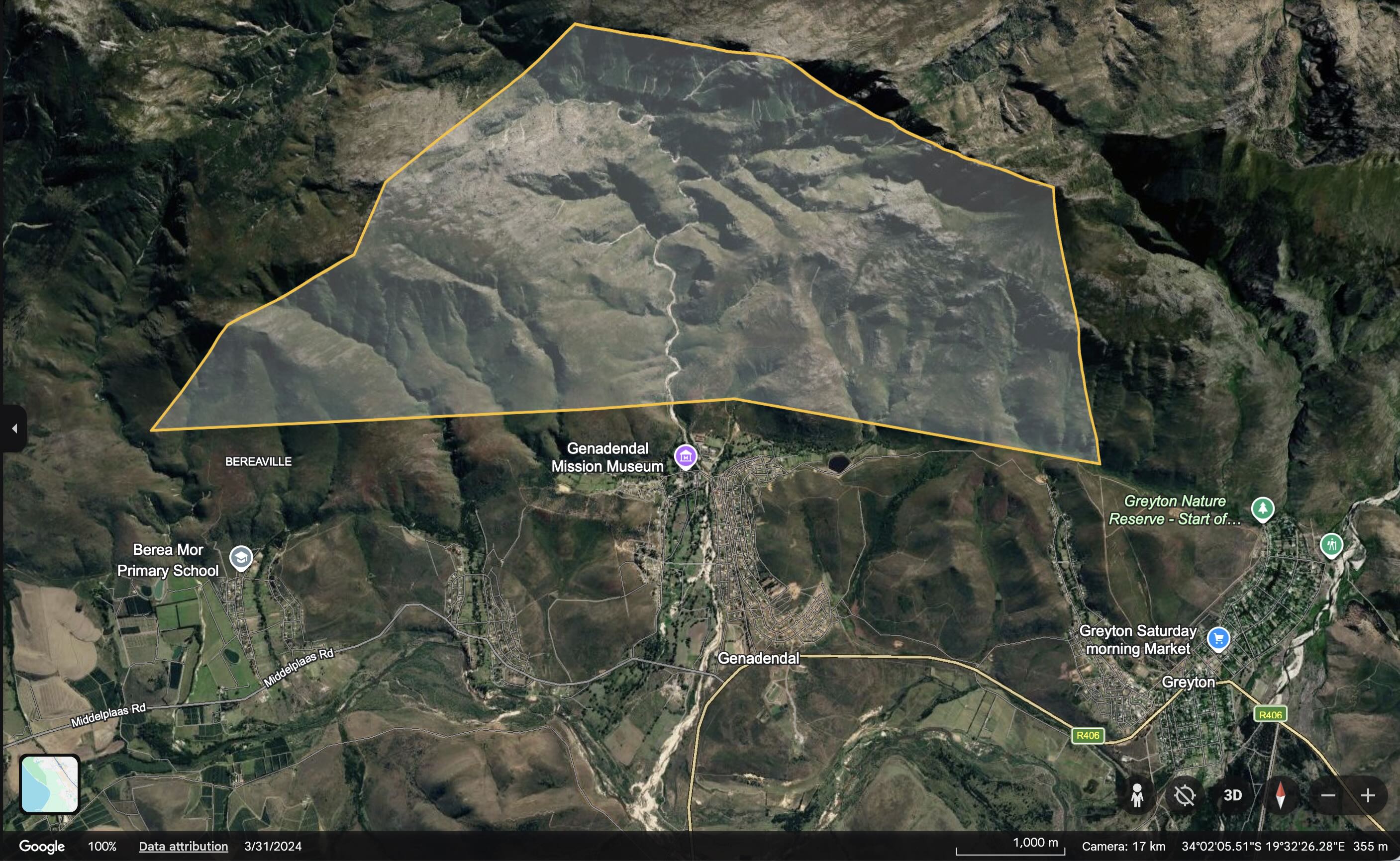
Langgezocht is Farm 32 in the Caledon registration division: the mountain land behind Genadendal, where the Baviaans River rises [MS]. The Moravian Church bought it in 1899 to protect the water sources of Farm 39 [MS]. The DevForum’s land table records it as CapeNature land today [MS]. How and when it changed hands has not yet been confirmed.
Map: see this property on the DevForum’s Google Earth map of the valley’s land, which shows the Surveyor-General boundaries of all eight properties.
What the letters in square brackets mean
Facts on this page are followed by a tag that shows where they come from.
- [IC] Independently Corroborated. Confirmed by at least two sources that do not depend on each other, or by an official record such as a Surveyor-General record or a law.
- [MS] Mission-Sourced. Comes from one party’s own documents or statements, or from the DevForum’s own research and maps. It has not been checked against other sources.
- [TBV] To Be Verified. Seems likely, but nobody has confirmed it yet.
At a glance
| Name in the Surveyor-General’s records | LANG GEZOCHT [IC] |
| Farm number | 32, Caledon registration division [IC] |
| Surveyor-General code | C01300000000003200000 [IC] |
| Area | 1,835.56 hectares on the DevForum’s map, from the Surveyor-General’s records [IC]; about 1,881 hectares in Moravian and Ward 2 Forum sources [MS] |
| Municipality | Theewaterskloof, Overberg District [IC] |
| Held by | CapeNature, according to the DevForum’s land table [MS] |
| Link to the valley | The catchment of the Baviaans River above Genadendal [MS] |
History
- 1899. The Moravian Church bought Langgezocht “in order to protect the water sources of Farm 39” [MS]. The Ward 2 Forum’s 2017 series and the register’s history pages both give it as 1,881 hectares [MS].
- Who bought it. The mission land below it was held by the church in trust for residents from 1858 [MS]. Langgezocht was a separate purchase, so it was never part of that trust land [MS]. Inference: it therefore sits outside the TRANCRAA process for Farm 39.
- After 1899. No record has yet been found of when the farm left the church, or how it came to CapeNature [TBV].
- Today. The DevForum’s land table lists Farms 32 to 38 together as CapeNature land, 5,230.29 hectares [MS]. Any work on Langgezocht needs CapeNature’s approval [MS].
On the DevForum’s map
- The farm lies north of Farm 39, in the mountains above Genadendal [MS].
- Three of the four dam-wall options drawn on the Baviaans in the DevForum’s map (B2, B3 and B4) fall inside Langgezocht [MS]. These are options drawn for the idea on Community-Built Dams on the Baviaans and Gobos, which the DevForum has not agreed.
What is still open
- When and how Langgezocht passed from the Moravian Church to CapeNature, and on what terms.
- Why the church’s figure of about 1,881 hectares differs from the 1,835.56 hectares on the Surveyor-General’s record.
- What water rights go with the farm, and in whose name they are registered.
- What the date on the Surveyor-General record (19 October 2015) marks.
Have your say
If you hold records of Langgezocht, or remember how it was used, contact the moderators via How to Submit.
Related
- Farm 39
- Farm 827: The Glebe Land
- CapeNature
- The Moravian Church
- National Water Act
- From Water Access to Water Agency
- All villages
References
- Chief Surveyor-General. Cadastral record for Farm 32, Caledon, shown on the DevForum’s Google Earth map of the valley’s land. The name, number, code and area.
- Ward 2 Forum. Farm 39 Transformation: The Lost 18 Years, Part 1 (28 March 2017). The 1899 purchase and 1,881 hectares. Register entry: Farm 39 Transformation: The Lost 18 Years.
- History of the Valley and The Moravian Church, and the sources listed there.
- Why Alien Clearing? The DevForum’s land table.