For the Moravian Church and the Transformasie Komitee to review
This page has not yet been checked by the bodies it names. Questions for them:
- For the Moravian Church: is Farm 827 the land granted to the church in 1927, and does it include all nine Glebe portions, or only those in Genadendal?
- For the Moravian Church: under which title deed is Farm 827 held, and where are the Bereaville portions recorded?
- For the Transformasie Komitee: is this how the Komitee understands the Glebe Land, and its place outside the TRANCRAA process?
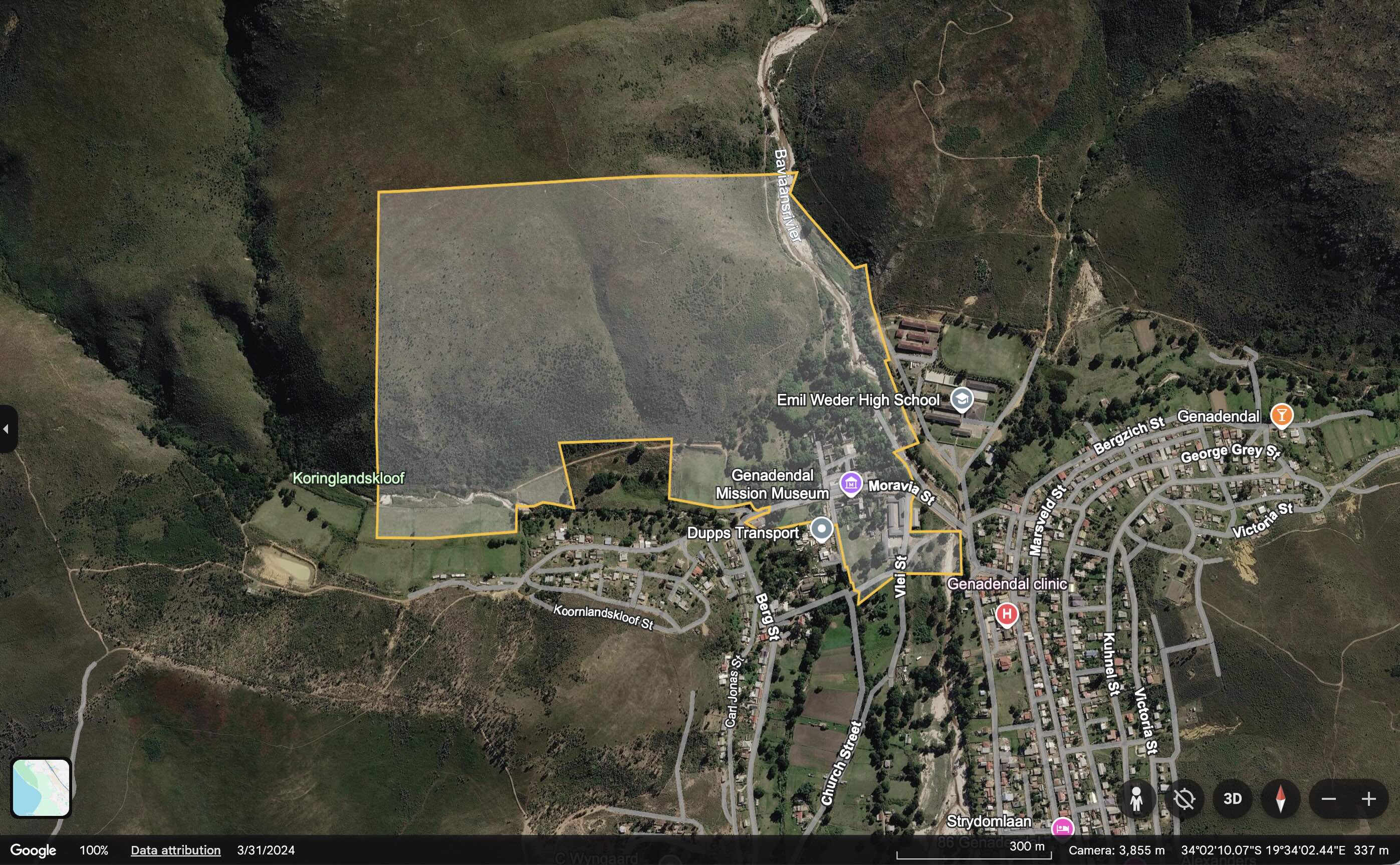
The Glebe Land is the land at the heart of Genadendal that was granted to the Moravian Church in 1927 [IC]. In the Surveyor-General’s records it is Farm 827 in the Caledon registration division, named “GLEBE LAND”, with an area of 61.11 hectares [IC]. It lies around the old mission core, and it is held apart from the trust land of Farm 39 [IC]. For this reason it is not part of the land whose transfer is being decided under TRANCRAA [IC].
Map: see this property on the DevForum’s Google Earth map of the valley’s land, which shows the Surveyor-General boundaries of all eight properties.
What the letters in square brackets mean
Facts on this page are followed by a tag that shows where they come from.
- [IC] Independently Corroborated. Confirmed by at least two sources that do not depend on each other, or by an official record such as a Surveyor-General record, a Deeds Office report or a court order.
- [MS] Mission-Sourced. Comes from one party’s own documents or statements, or from the DevForum’s own research and maps. It has not been checked against other sources.
- [TBV] To Be Verified. Seems likely, but nobody has confirmed it yet.
At a glance
| Name in the Surveyor-General’s records | GLEBE LAND [IC] |
| Farm number | 827, Caledon registration division [IC] |
| Surveyor-General code | C01300000000082700000 [IC] |
| Area | 61.11 hectares on the DevForum’s map, from the Surveyor-General’s records [IC]; 68 hectares in the Ward 2 Forum’s 2017 series [MS]; 70.7795 hectares in the consultants’ 2010 report [MS] |
| Held by | The Moravian Church, since 1927 [IC] |
| Status under TRANCRAA | Outside the trust land of Farm 39 [IC] |
History
- 1737 to 1858. The mission at Baviaanskloof, later Genadendal, was founded in 1737, and its church, school, workshops and houses grew around Church Square [IC]. In 1858 the whole mission land was granted to the church “in trust for” its residents [MS]. The grant confirmed the institution’s “full possession of the church, schools, workshops, houses, gardens, plantations of trees, water leadings and other property hitherto occupied by them” [MS].
- 1909 and 1924. The Mission Stations and Communal Reserves Act of 1909 placed mission land under a management board, and a secular board replaced the missionaries in 1924 [IC]. Balie’s history says the 1909 Act gave the mission title to its church, school and houses, and reserved the rest for registered occupiers [MS].
- 1927. Title to the core mission areas of Genadendal and Bereaville was granted free of charge to the Moravian Church [IC]. The Ward 2 Forum’s 2017 series, drawing on a 2000 report for the church by the Surplus People Project and the Legal Resources Centre, describes this as “nine portions of land, known as the Glebe Lands” [MS].
- 1952. The state’s deed of grant for Farm 39 (G19/1952) gives the farm’s extent as 4,772.97 hectares [IC]. The consultants’ 2010 report states that this figure excludes “the Glebe Land of 70,7795ha” [MS].
- Farm 827 grows. The Deeds Office search report attached to the 2008 court order records Portions 3 to 7 of Farm 39, about 2.34 hectares together, as “Consol to Farm 827” [IC]. Inference: small pieces of Farm 39 were added to the Glebe Land at some date before 2007.
- 1980 to 1991. The buildings on Church Square were declared national monuments in 1980, and the Mission Museum opened in the 1838 college building in 1987 [MS]. The mission buildings around Church Square are now a Provincial Heritage Site [IC].
- Today. The Ward 2 Forum’s 2017 series describes the trust lands as Farm 39 “excluding the Glebe Lands”, which it says belong to the Moravian Church [MS].
On the DevForum’s map
- Farm 827 is a single parcel around the mission core of Genadendal [MS]. The DevForum’s map point for the historic centre of Genadendal falls inside it [MS].
- The parcel does not reach Bereaville [MS]. Inference: if the 1927 grant included land in Bereaville, that land is either recorded under another number or no longer held as Glebe Land.
What is still open
- Whether Farm 827 holds all nine of the 1927 portions, and where the Bereaville portions are recorded.
- Why the areas differ: 61.11 hectares on the Surveyor-General’s record, 68 hectares in the 2017 series, and 70.7795 hectares in the consultants’ report.
- When Portions 3 to 7 of Farm 39 were added to Farm 827, and on whose application.
- The title deed under which the church holds Farm 827.
- What the date on the Surveyor-General record (8 December 2025) marks.
Have your say
If you hold records of the Glebe Land, contact the moderators via How to Submit.
Related
- Farm 39
- Genadendal
- Bereaville
- Farm 32: Langgezocht
- TRANCRAA and Farm 39: The Land Transfer Process
- The Moravian Church
- Moravian Church Genadendal
- Genadendal Mission Museum
- All villages
References
- Chief Surveyor-General. Cadastral record for Farm 827, Caledon (“GLEBE LAND”), shown on the DevForum’s Google Earth map of the valley’s land. The name, number, code and area.
- Order of the High Court, case 926/07, 22 October 2008, with Annexure GT1, the Deeds Office search report on Farm 39 as at 25 April 2007. Held by the DevForum; listed on the archived legal reference page. Portions 3 to 7 consolidated into Farm 827, and Deed of Grant G19/1952.
- Urban Dynamics Western Cape. Genadendal Transformation: Executive Summary and Recommendations (October 2010). Held by the DevForum. The Glebe Land of 70.7795 hectares.
- Ward 2 Forum. Farm 39 Transformation: The Lost 18 Years, Part 1 (28 March 2017). The nine portions and the 1858 grant. Register entry: Farm 39 Transformation: The Lost 18 Years.
- Balie, I. (2023). Genadendal, The Valley of Grace: A Long Walk. AuthorHouse. The 1909 Act. See Genadendal: A Long Walk.
- History of the Valley, and the sources listed there.