Heuwelkroon, Boschmanskloof, and Madiba Park lie next to each other on the edge of Greyton [MS]. People who are new to the valley often see them as one neighbourhood of Greyton. On paper they are three different cases. Heuwelkroon is part of Greyton [IC]. Boschmanskloof is part of Genadendal [IC]. Madiba Park stands on Farm 39 land held in trust by the national government, and the municipality has said it cannot provide full services there because the land is not the municipality’s [MS]. This page explains what that means for anyone who wants to help.
What the letters in square brackets mean
Facts on this page are followed by a tag that shows where they come from.
- [IC] Independently Corroborated. Confirmed by at least two sources that do not depend on each other, or by an official record such as a court order, a law, or a municipal plan.
- [MS] Mission-Sourced. Comes from one party’s own documents or statements, or from the Forum’s own notes. It has not been checked against other sources.
- [TBV] To Be Verified. Seems likely, but nobody has confirmed it yet.
Advice on how to get involved carries no tag. Which way of deciding a place or an event belongs to is the Forum’s reading of the history, and carries no tag either.
The lay of the land
The Greyton Governance Map, developed by W2DF, shows how closely the three settlements fit together [MS]. The sizes and distances below are an AI-generated simplification from the Google map linked above.
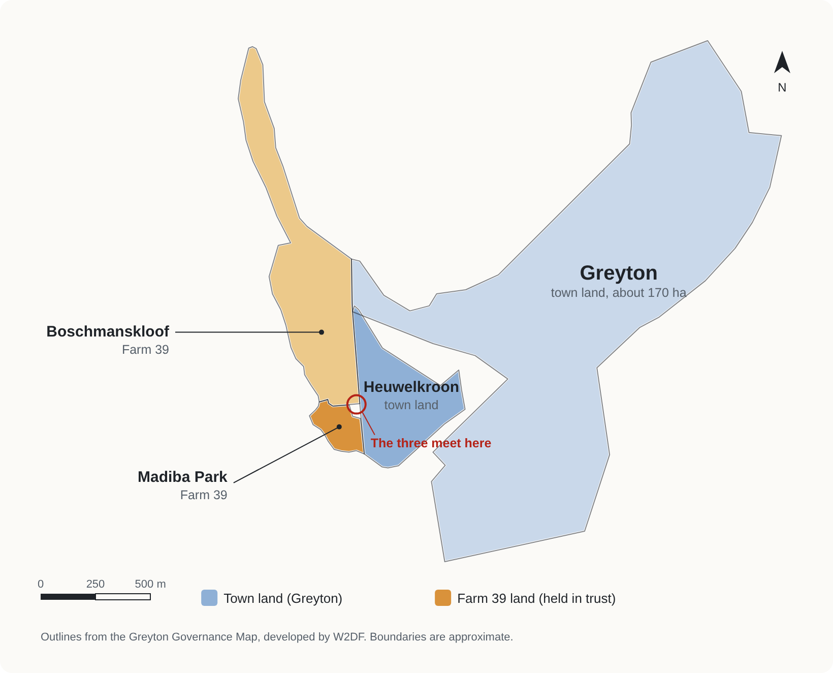
- Heuwelkroon covers about 19 hectares on the south-western edge of Greyton [MS].
- Boschmanskloof is a long, narrow strip of about 32 hectares on Greyton’s western side, running about 1.6 kilometres north up the kloof [MS]. Its eastern edge borders Heuwelkroon for more than 400 metres, and Greyton for about 250 metres [MS].
- Madiba Park covers about 4 hectares at the southern tip of Boschmanskloof [MS]. It shares about 170 metres of boundary with Heuwelkroon and about 160 metres with Boschmanskloof [MS]. Its nearest edge is about 300 metres from Greyton [MS].
The three settlements meet near a single corner [MS]. From the middle of Madiba Park to the middle of Heuwelkroon is about 300 metres [MS].
At a glance
| Heuwelkroon | Boschmanskloof | Madiba Park | |
|---|---|---|---|
| Size on the Greyton Governance Map | About 19 hectares [MS] | About 32 hectares [MS] | About 4 hectares [MS] |
| Part of | Greyton [IC] | Genadendal [IC] | A settlement of its own. Its place between Greyton and Genadendal is contested [MS] |
| The land | Greyton town land, which the municipality plans and builds on [IC] | Farm 39, part of the TRANCRAA process [MS] | Farm 39, with the national department as custodian [IC] |
| Municipal services | Linked with Greyton’s [IC] | Linked with Greyton’s and Heuwelkroon’s [IC] | Some toilets and water tanks; no full services [MS] |
| Talk to first about anything on the land | Theewaterskloof Municipality | The Transformasie Komitee | The Transformasie Komitee |
One ward, two kinds of land
Theewaterskloof Municipality is the local government for both Greyton and Genadendal [IC]. Ward 2 covers all seven settlements, including these three [MS]. What sets Heuwelkroon, Boschmanskloof, and Madiba Park apart is the land they rest on.
Farm 39 is the legal name for a piece of land [IC]. It has no council of its own [MS]. The national Minister responsible for land reform holds most of it in trust for the people who live on it [IC]. A law of 1998, known as TRANCRAA, says this land must pass to an owner the residents help choose [IC]. That transfer has not happened [IC]. In 2004 residents elected the Transformasie Komitee to take part in the process for them [IC]. The full story is on TRANCRAA and Farm 39: The Land Transfer Process.
Greyton was laid out as a freehold town, where owners hold title deeds [IC]. The municipality plans and builds on Greyton’s land in the usual way. On Farm 39 it works with the Komitee and with the national department, which holds the land [IC].
Heuwelkroon: part of Greyton
Heuwelkroon was built as a township on the edge of Greyton for coloured families who were forced out of Greyton under the Group Areas Act [IC]. Sources date the removals to between the late 1960s and the early 1970s [TBV]. Until the mid-1990s Heuwelkroon had its own management committee under Greyton’s white town council [IC].
Today the municipality’s spatial plan treats Heuwelkroon as part of Greyton, with its own business area and sports fields [IC]. The municipality can plan and build here. In July 2025 the province authorised it to build 333 homes on Erf 595 in Heuwelkroon [IC]. The story of the removals is on History of Greyton.
Boschmanskloof: next to Heuwelkroon, part of Genadendal
Boschmanskloof borders Heuwelkroon [MS]. Its land is part of Farm 39 [MS]. The municipality’s spatial plan says that “although the settlement forms part of Genadendal, it has historically been segregated” [IC]. The plan says Boschmanskloof “was initially established as an extension of the Genadendal Mission” [IC].
The same plan describes “the inter-linked nature of civil services between Greyton, Heuwelkroon and Boschmanskloof” [IC]. It calls for closer links between Boschmanskloof and Greyton, so that the two do not duplicate public facilities [IC]. Boschmanskloof has three seats on the Transformasie Komitee [MS].
So Boschmanskloof’s services are tied to its neighbours in Greyton [IC], while its land belongs to the Farm 39 process with Genadendal [MS].
Madiba Park: on Farm 39, without full services
Madiba Park borders Heuwelkroon [MS]. It stands on Farm 39 land [IC], and the national Department of Agriculture, Land Reform and Rural Development is the custodian of that land [IC]. People have lived there for more than ten years [TBV]. In 2024 the municipality counted more than 175 structures, and residents said there were more than 220 homes [MS].
In 2024 the municipality told GroundUp that it could not provide full services because “the settlement is not on municipal land” [MS]. GroundUp reported five toilets and some water tanks on the edge of the settlement, kept by the municipality under an agreement with the Komitee, and found one toilet working [TBV]. The full record is on Madiba Park: Land Status and Basic Services.
What happened when people tried to fix things
The record since 2008 shows how many parties even a small fix in Madiba Park involves. Each party is described here only through what it has said or done.
- 2008. The Komitee obtained a High Court order about Farm 39 land [IC]. GroundUp reported in 2019 that this order stops the municipality from using the land at Madiba Park [TBV].
- January 2019. Chemical toilets were removed on 13 January and the water was cut off on 14 January. Residents protested [IC].
- January 2019. The municipality said it had “appealed many times to the Department of Rural Development and the GTC to let the residents of Madiba Park stay there temporarily” [MS]. GTC stands for the Genadendal Transformation Committee, the Komitee’s name in English.
- January 2019. The Komitee’s treasurer told GroundUp: “We want [the occupiers] off our land, onto municipal land” [MS]. GroundUp reported that the Komitee would go to court if the municipality put in water or sanitation there, because the land did not belong to the municipality [MS].
- 2022 to 2023. The municipality budgeted R1.6 million to bring electricity to Madiba Park [IC]. The budget was cut in February 2023, and R73,135 was spent [IC].
- September 2022. The DA’s Western Cape spokesperson on human settlements said the municipality had written twice to the national Minister asking permission to install interim basic services, and had received no reply [MS].
- May 2024. The Komitee’s treasurer told GroundUp: “We don’t want to evict people, we want to relocate them” [MS]. A municipal spokesperson said the environmental assessment for new housing had caused delays [MS].
In Madiba Park, even a toilet or a water tank has involved the municipality, the Komitee, and the national department [IC]. Each of them has a legal role in that land.
Why a quick fix meets more than one way of deciding
This site reads the valley’s history through the TIME model. TIME describes four ways people organise themselves, and each has its own way of settling a question [MS].
| Way of deciding | TIME form | Who or what settles a question |
|---|---|---|
| Kin and belonging | T | Elders and families, drawing on who belongs and what the group has always shared |
| Rules and office | I | An office-bearer, working under written rules |
| Price and trade | M | A price that a buyer and a seller agree on |
| Working it out together | E | Nobody presides. The people affected shape the answer together. |
The three settlements came to their land at different times, under different ways of deciding. The Valley Through TIME sets out the full reading.
- Boschmanskloof and Madiba Park stand on land granted in trust for its residents in 1858 [MS], which has still not been transferred to them [IC]. In the Forum’s reading, rules and office still decide who may hold this land, while wages and prices shape daily life here as they do across the valley.
- Heuwelkroon was made by rules and office, when the Group Areas Act moved coloured families out of Greyton [IC]. Today it is part of Greyton, where land has been property that can be bought and sold since 1854 [IC].
- In all three, families, congregations, and neighbours still organise through kin and belonging, in the Forum’s reading.
A newcomer who sees a broken tap in Madiba Park may reach for the ways that work at home in Greyton: buy the parts, or phone the municipality. On Farm 39 land those routes meet others. The national department holds the land in trust [IC], and residents elected the Komitee to take part in its transfer [IC]. The residents of each settlement also have their own account, which this page has not yet recorded.
In the Forum’s reading, each way of deciding works best among people who already accept how it settles things [MS]. When two ways meet, one usually becomes the host, and the other takes part on the host’s terms [MS]. A fix that arrives already decided makes the newcomer’s way the host, however well it is meant.
Michael Haupt describes this in an essay about the Forum’s first meeting, Using TIME for difficult decisions. He brought a prepared proposal to that meeting, and participants from the valley asked that the communities a proposal affects help shape it from the start [MS]. The Forum agreed [MS]. In the essay he argues that the Emergent way, working it out together, has no tie-breaker, because it brings all four ways into one room with none of them presiding [MS]. The Forum’s reasons for its rule are on Why the Forum Shapes Proposals Together.
Before you start something here
- Check which settlement you are in. Each has its own page, listed on Villages.
- In Heuwelkroon, questions about land, housing, roads, and water go to Theewaterskloof Municipality.
- In Boschmanskloof and Madiba Park, anything that touches the land goes to the Transformasie Komitee first. That includes building, fencing, food gardens on open ground, water, toilets, and clearing a site. This register sends every entry of this kind to the Komitee for review before it is published.
- In Madiba Park, speak with residents before planning anything for them. This register keeps one rule for every page: no proposal about a group of people without that group present.
- Bring people in before anything is written. The Forum has agreed that the communities a proposal affects should help shape it from the start. A plan that arrives finished is harder to shape together, even when it is a good plan.
- Bring your idea to the Forum. The Ward 2 Development Forum works across the whole valley, and can bring the right people into one room. See How to Submit.
What is still open
- Whether the line the Greyton Governance Map draws between Heuwelkroon and Boschmanskloof follows the official boundary between Greyton and Genadendal. A survey in 2005 confirmed the fence between Genadendal and Greyton as the boundary [IC], and this page has not yet compared the two.
- Whether Boschmanskloof lies inside one of Farm 39’s township areas. Under TRANCRAA, trust land inside a proclaimed township passes to the municipality [IC], so the answer decides who will own the land under Boschmanskloof’s houses.
- Which services the municipality provides in Boschmanskloof today, beyond the links its spatial plan describes.
- Whether Madiba Park households will be housed on Erf 595 in Heuwelkroon.
- The accounts of residents of all three settlements, in their own words.
- The accounts of the Transformasie Komitee and Theewaterskloof Municipality, which have not yet been asked to review this page.
Have your say
If you live in Heuwelkroon, Boschmanskloof, or Madiba Park, or represent a body named here, the moderators would like to hear how you see it. Contact them through How to Submit. Accounts are added in the words of the people who give them.
Related
- Heuwelkroon
- Boschmanskloof
- Madiba Park
- Farm 39
- Greyton
- Genadendal
- Madiba Park: Land Status and Basic Services
- TRANCRAA and Farm 39: The Land Transfer Process
- Genadendal Transformasie Komitee
- History of Greyton
- The TIME Model
- The Valley Through TIME
- Why the Forum Shapes Proposals Together
- How the Forum’s Categories Compare
- How the Forum Decides Together
- Theewaterskloof Municipality
- All villages
References
Official records:
- Theewaterskloof Municipality. Spatial Development Framework, Chapter 11: Greyton (final, November 2019). Boschmanskloof as part of Genadendal (11.1.2), integration with Greyton (11.1.4), its origin as an extension of the mission (11.5.6), shared civil services (11.6.1), and Heuwelkroon’s business area and sports fields.
- Western Cape DEADP. Environmental Authorisation, Integrated Housing Development on Erf 595, Heuwelkroon, Greyton (10 July 2025). Authorisation for 333 homes.
- Theewaterskloof Municipality. Adjustment Budget 2022/23 (23 February 2023) and Financial Report, Fourth Quarter 2022/23. The Madiba Park electrification budget and what was spent.
- Land Claims Court. Genadedal Transformation Committee and Others v Theewaterskloof Municipality and Others (LCC64/2014) [2014] ZALCC 14. The 2008 settlement order and the Minister’s trust over Farm 39.
Forum documents:
- Ward 2 Development Forum. Greyton Governance Map (Google My Maps, 2026). Outlines of Greyton, Heuwelkroon, Boschmanskloof, and Madiba Park. The diagram, areas, and boundary lengths on this page are drawn and measured from it.
The TIME model:
- Framer OS. Using TIME for difficult decisions (27 September 2026), by Michael Haupt. The Forum’s first meeting read through TIME, and why the Emergent way has no tie-breaker.
- BioConomy wiki. The TIME Framework. The full framework.
News reports and statements:
- GroundUp. Conditions in Greyton settlement worsen as land restitution process drags on (30 May 2024). The municipality’s statement on municipal land, the toilets and water tanks, structure counts, and the Komitee’s statement on relocation.
- GroundUp via Daily Maverick. Greyton residents caught in the middle of a political battle (21 January 2019). The toilet removal, the 2008 order, and statements by the municipality and the Komitee.
- Polity. DA statement: Instead of mudslinging, ANC WC should urge Didiza to bring dignity to Madiba Park residents (29 September 2022). The municipality’s letters to the national Minister.