This idea is not yet agreed. Nobody named on this page has been asked about it yet. That includes the Zonderend Water Users Association, whose work and photographs it describes, the Genadendal Transformasie Komitee, the Greyton Conservation Society, Theewaterskloof Municipality, Greyton’s tourism businesses, including the Greyton Tourism Bureau and Adventure Hub Greyton, and the people who hold land along the rivers. Some of the rivers around Genadendal run through Farm 39 land, so the idea goes to the Transformasie Komitee in writing first. It can be tabled at a DevForum meeting once the Komitee responds, or 21 days after it was sent, whichever comes first. Please do not share this page publicly yet.
What the letters in square brackets mean
Facts on this page are followed by a tag that shows where they come from.
- [IC] Independently Corroborated. Confirmed by at least two sources that do not depend on each other, or by an official record.
- [MS] Mission-Sourced. Comes from the people putting this idea forward, or from the organisation the sentence names, in their own documents or statements. It has not been checked against other sources.
- [TBV] To Be Verified. Seems likely, but nobody has confirmed it yet.
Statements without a tag are proposals. They describe what the idea could become.
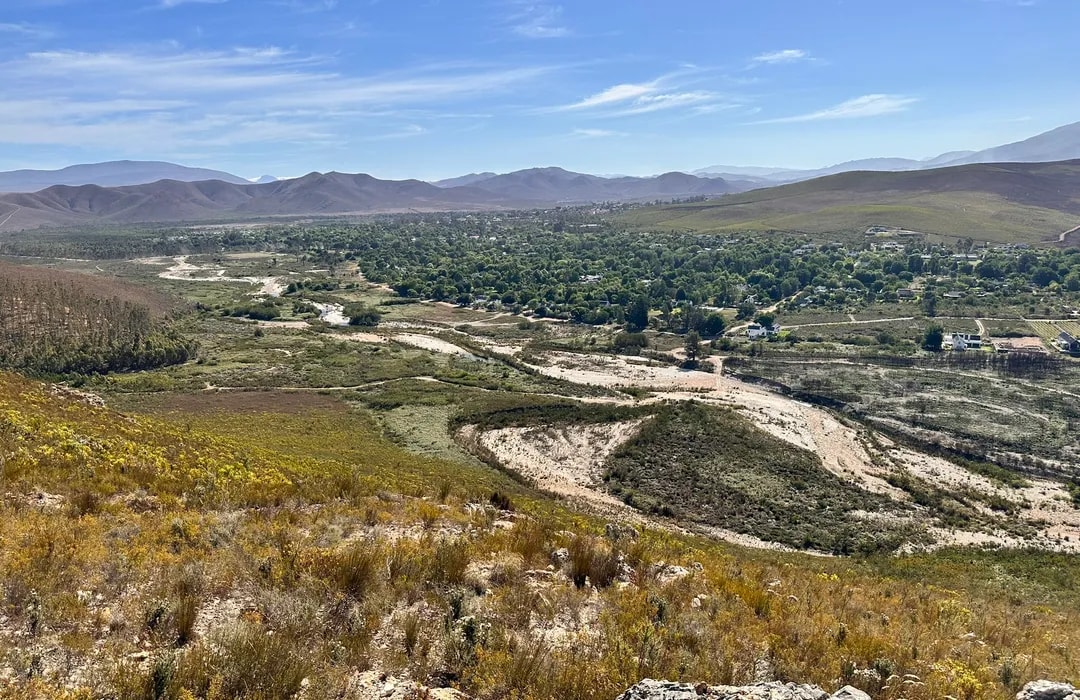
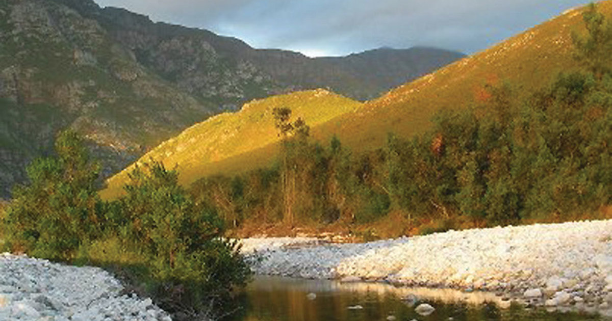
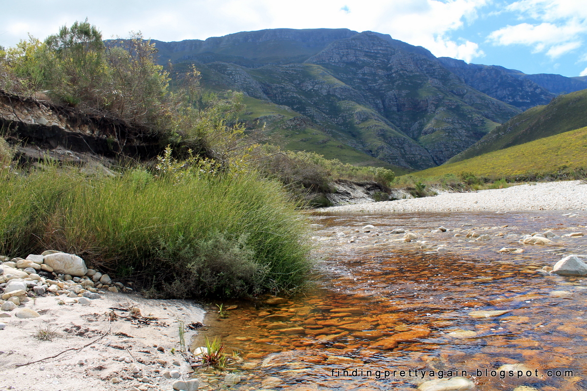
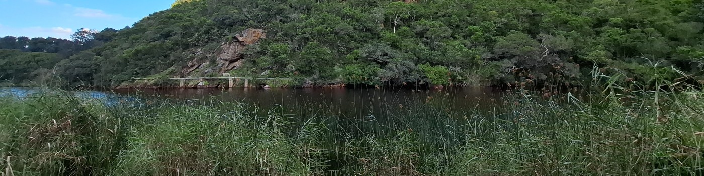
The Palmiet Principle is a proposed way for the valley to notice and reward any act that helps bring its rivers back to life. It is named after palmiet, the plant that holds the banks of healthy Cape rivers together. The idea measures progress against two sets of photographs. Category A shows rivers around Genadendal and Greyton as they are today [MS]. Category B shows mainly a stretch of the Riviersonderend upstream of the valley, which the Zonderend Water Users Association has brought back to life by planting palmiet [MS]. The idea asks how every river in the valley could move from the first set to the second, and how each step on the way could be seen and rewarded.
The goal
Every stretch of river in the valley moves from Category A to Category B, one act of care at a time, and each act is seen by the people who live along it.
Why the valley needs it
Category A: the rivers today
Floods have washed tons of rock down from the mountains and left it lying in the riverbeds [MS]. Where that has happened, a river is hard to use and unpleasant to look at [MS]. In the Category A photographs the banks are bare sand or loose stone [MS].
Category B: what a river can become
The Zonderend Water Users Association grows palmiet and other indigenous plants at its nursery in Genadendal, and replants cleared riverbanks with them [MS]. The stretch upstream of the valley where it has done this is the main source of the Category B photographs [MS]. In them the banks are held by plants, and the water runs clear [MS].
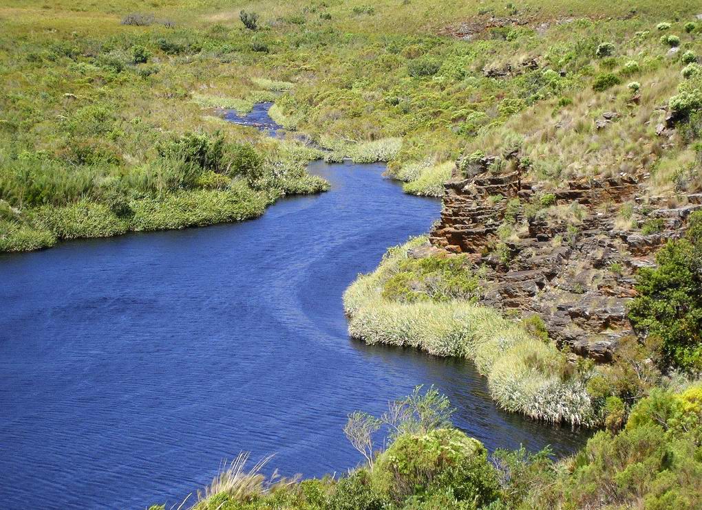
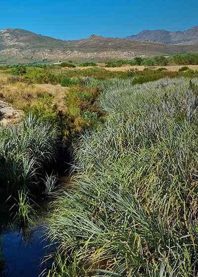
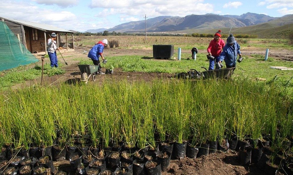
What palmiet does for a river
Palmiet (Prionium serratum) is found only in South Africa, from the Western Cape to KwaZulu-Natal [IC]. It grows up to about 2 metres tall, often in large, dense stands in marshes, streams and rivers and on their banks [IC]. It grows quickly, and new plants can be made by dividing old ones [IC]. Its dense stands slow a river’s flow and form wetlands, which is why researchers call it an ecosystem engineer [IC]. The South African National Biodiversity Institute describes it as an “organic engineering material” that can bind riverbanks and guide the flow of water [MS].
- It holds the banks. Palmiet helps hold river beds and banks against erosion [IC]. Its thick roots let it withstand high floods [IC].
- It traps sediment and builds land. Palmiet traps large amounts of sediment in floods, and its long stem can be buried under metres of sand while the crown grows up through it [IC]. It helps eroded gullies fill in and heal [IC].
- It gets going quickly. A seedling looks like a small adult plant within four weeks of sprouting, so it can take hold before the next flood [IC].
- It bends with a flood. When the water rises, its stems fold back against the banks, so it does not block the river [TBV].
- It slows the water and stores it. Palmiet wetlands greatly reduce the damage floodwater does [IC]. They hold water in the wet season and let it out slowly in the dry season, keeping a steady flow in the river between rains [IC]. Studied on the Krom River, they are fed by groundwater seeping from the sandstone mountains around them [IC].
- It comes back after fire. Palmiet survives fire, and fire seems to make it flower and sprout more [IC].
- It needs sun. Palmiet grows well in direct sunshine and does not thrive in shade [IC]. Clearing invasive trees from a riverbank gives it room to return.
- It cleans the water. Its leaves may hold back chemicals and bacteria in the wetland [TBV].
- Its loss shows. Where palmiet is removed, banks erode, and streams and dams fill with sediment [IC].
Palmiet is declining in some places because of overgrazing, frequent fires, water taken from rivers, pollution and invasive plants [IC]. It is already used to repair damaged riverbanks in the Western Cape, including on the Duiwenhoks River [TBV].
A 2019 study for the Water Research Commission found that gullies cutting through palmiet wetlands are part of a natural cycle: much of the eroded sand settles just downstream, where a new wetland can form [IC]. Concrete or gabion structures stop existing wetlands being lost, but they also hold back that cycle [IC]. The study advises restoration that keeps the places downstream fit for palmiet to return, using softer structures that let some sediment move on [IC]. Leaky dams of stone, logs or brush fit that advice better than solid walls do.
What broken windows policing got wrong
In 1982 James Q. Wilson and George Kelling argued that a broken window left unrepaired tells passers-by that nobody cares, which invites worse damage [IC]. Police in the United States used the idea to arrest people for small offences, in the belief that this would prevent serious crime [IC].
Later research found a different pattern. In a study of Chicago neighbourhoods, Robert Sampson and Stephen Raudenbush found that crime and visible disorder were both lower where neighbours trusted each other and were willing to act for the common good [IC]. Disorder itself did not drive most crime [IC]. A 2024 review of the research found that aggressive order maintenance did not reduce crime significantly [IC]. The strongest results came from work with communities to solve the problems behind disorder in a place [IC].
One part of the old idea holds up. People read a place for signs that someone cares for it. The landscape researcher Joan Nassauer found that people accept and look after a wild-looking landscape more readily when it shows clear signs that someone tends it [IC]. She called these cues to care [IC].
The Palmiet Principle keeps the cues to care and drops the punishment.
The idea
The people putting this idea forward take palmiet as the model [MS]. Palmiet does not need people to build a wetland for it. Once a plant takes hold, it slows the water and traps sand, and the land it builds gives the next plant a place to root [IC]. A river recovers through many small gains of this kind. Broken windows policing assumed that each act of neglect makes the next one easier. The Palmiet Principle assumes the same of care: each act that people can see makes the next act more likely.
What counts
Any act that helps a river move towards Category B, done with the agreement of whoever holds the land:
- planting palmiet or other indigenous plants from the Zonderend Water Users Association nursery;
- pulling up seedlings of invasive trees before they grow;
- stuffing a gully to make a leaky dam (see Community-Built Dams on the Baviaans and Gobos);
- picking up litter in and along a river;
- taking a photograph of a stretch from the same spot each season;
- showing a younger person how to do any of these;
- a farm, school, congregation or business adopting a stretch of river and caring for it over years (see Adopt a River below).
How care is seen
- A river log. Each act is marked on a shared map of the valley’s rivers, stretch by stretch, with the person’s name if they want it shown.
- The same photograph, every season. Each adopted stretch is photographed from a fixed spot four times a year. Over time the photographs show any move from Category A to Category B, for anyone to see.
- A yearly river walk. People walk the adopted stretches together, look at the photographs, and thank those who did the work.
How the rewards work
There are two levels.
For a person, recognition. A person who cares for a river is seen and thanked, on the river log and on the river walk. No one is paid per act. A review of 128 experiments found that tangible rewards for a task tended to lower people’s own wish to do it, while positive feedback tended to raise it [IC].
For a stretch of river, a shared pool. Any money or goods that come in for a stretch go into a pool for that stretch. That could include payments for water, support from a sponsor, or a business that adopts the stretch. The people who care for the stretch decide together how the pool is spent: plants, tools, a school outing, or work they cannot do by hand. This follows the idea of Commitment Pooling, in which people pool what they can offer and draw on what the pool holds.
People who are already paid for river work, such as clearing teams, keep their wages. The river log and the river walk recognise their work as well.
Adopt a River: a sponsorship for Greyton’s tourism businesses
Tourism businesses in Greyton could adopt a stretch of river and sponsor its care. Greyton was laid out in the 1850s beside the Gobos River, and its plots have drawn Gobos water through the leiwater furrows since 1854 [MS]. The Integrated Development Plan describes Greyton as “a retirement and holiday home base” [IC]. Visitors who come for the village walk past rivers that are still in Category A.
What a sponsor would give
- A yearly contribution to the pool for its stretch. The money stays with that stretch, and the people who care for it decide how to spend it.
- Time from its own staff, such as one morning on the river each season.
- If it wishes, the help of its guests on a planting morning or the yearly river walk.
What a sponsor would receive
- Its name on the river log, and on a small sign at its stretch where the landholder agrees. The sign is itself a cue to care: it tells every passer-by that someone looks after this stretch.
- The seasonal photographs of its stretch, which it may share with guests and on its own channels.
- An experience to offer guests: planting palmiet from the Zonderend Water Users Association nursery with the people who care for the stretch. Visitor information points such as the Greyton Tourism Bureau and Adventure Hub Greyton could list these mornings.
The rules of adoption
- A sponsor adopts the care of a stretch. It does not gain any right over the land or the water.
- Staff from the sponsor who take part in the work join the others who care for the stretch in deciding how its pool is spent. The size of a contribution buys no larger say.
- The sign stays up for as long as the sponsor keeps up its part. The seasonal photographs show the stretch as it is, so recognition follows the care the river actually receives.
- A Greyton business could also adopt a stretch elsewhere in the valley, where the people who hold the land agree. On Farm 39 land, the Transformasie Komitee is asked first.
What it never does
Nobody is fined or patrolled, and nobody who damages a river is named. When a stretch is damaged, the people who care for it repair it together and ask what led to the damage.
The inner side: Vorming
Bildung is a German word for the way a person forms themselves through learning and experience over a lifetime [IC]. The valley’s own variation of it is called Vorming, the Afrikaans word for formation, and is built on care for the valley and on ecological restoration (see Vorming). The people putting this idea forward use Vorming as a design principle for every initiative in the valley [MS]. They hold that the state of a river reflects an inner shift in the people who live along it, and that a river moves from Category A to Category B as people change the way they see it and treat it [MS].
On this view, the river log and the river walk serve that inner change. They help a person notice that they have become someone who looks after the river.
The Class 6 Project is designed to show this in practice [MS]. The children are not taught the idea of Vorming. They work with their hands on the river and on a map of the valley, and the river is left to show what changed.
Why it matters for funding
Large sums are being set aside for nature in South Africa, and the valley’s Category A rivers are the kind of place they are meant for. The Biodiversity Finance Plan of 2018, prepared with the United Nations Development Programme’s Biodiversity Finance Initiative, put forward 16 ways to pay for the country’s biodiversity work [MS]. Among them are water tariffs that pay for catchments, and better-funded stewardship of land by the people who own and use it [MS]. The Cape Water bond is one example of catchment finance already running in the province [MS]. The draft national biodiversity plan for 2026 to 2035 calls for funding that lasts beyond project cycles, and for budgets set aside for biodiversity work led by communities [MS]. A new finance plan is being prepared, built around a facility that would pool public and private money for restoring land and caring for catchments [MS]. See Department of Forestry, Fisheries and the Environment.
The people putting this idea forward hold that money on this scale will reach the valley only if, as a community, it holds this way of thinking about the world and about each other [MS]. Stewardship funding pays for care that lasts and can be shown. A grant can pay for one season of planting, and the river needs people who keep caring for it after the grant ends.
The Challenges record shows why this matters here:
- Damaged land with no record. The Gobos River on Erf 595 is deeply eroded [IC]. No valley-wide data on erosion was found, and no map of land taken over by invasive plants [TBV]. See Challenges: Ecological ceilings and Why Alien Clearing?. The river log and the seasonal photographs would start that record, kept by residents.
- Assets lying idle. Community gardens in the valley lie fallow, as the DevForum heard at its first meeting [MS]. Land that nobody tends is a Category A problem of its own, and the same habits of care apply to it.
- How the valley is seen. The Financial Recovery Plan names Genadendal mainly as a debt problem, and the Integrated Development Plan describes its economy as “dominated by ‘development’ projects” [IC]. See Challenges: How the valley is seen. A valley that can show years of its own restoration work speaks to funders as a partner. See Needed vs Needy on the BioConomy wiki.
- One ward, many places. Official figures blend the seven settlements into one ward [IC]. A river log kept stretch by stretch would show what each settlement has done, as The Yearly Valley Survey would for households.
Who would benefit
- People downstream, including farmers and the holders of Greyton’s leiwater rights, if restored banks hold more water in the dry months.
- Learners, who could adopt a stretch and watch it change over the years they are at school.
- The Zonderend Water Users Association, whose nursery could supply plants for each new stretch.
- Guesthouses and other tourism businesses, if their guests can swim in and walk along healthier rivers, and through the visitor experiences an adopted stretch would offer.
Who would pay
Nothing has been costed. The river log and the river walk would cost very little, and so would the seasonal photographs. Plants from the nursery would have a cost, which is not yet known. No source of money for the pools has been found. Sponsorships under Adopt a River could be the first, once the DevForum sets what a yearly contribution would be. Why it matters for funding, above, names the national plans that could become one. The Cape Water bond pays for clearing invasive trees (see Why Alien Clearing?). Whether it, or any other fund, would pay for palmiet planting has not been asked.
Who would decide
- Each stretch of river: whoever holds the land beside it. On Farm 39 land, the Transformasie Komitee is asked first.
- Work in a river: whether planting in a riverbed needs a permission under the National Water Act has not been checked [TBV].
- Each pool: the people who care for that stretch, under simple rules the DevForum would agree.
How it fits the DevForum’s goal
The idea serves the Conservation and Environment priority, because it would restore rivers and their banks. It serves the Tourism Development priority, because Adopt a River would give Greyton’s tourism businesses a stake in the rivers their visitors see, and a new experience to offer them. It serves the Education and Skills priority, because schools could adopt stretches and learn from them. It also fits Our Long-Term Goal, which plans for the valley to keep more of what it has, including water in the ground.
What is still open
- Individual credits. Whether people should also earn credits in a commitment pool for their own acts, or receive recognition only.
- The Zonderend Water Users Association’s view. Whether it agrees to its stretch and its nursery being used as the model, and whether it could supply plants on this scale. It has not been asked.
- The photographs. Some of the photographs on this page were taken by other people, and at least one carries the mark of a blog. The photographers’ permission and credits are needed before the page is shared publicly.
- Which stretches first. Which stretches of the valley’s rivers to start with, and who holds the land beside each.
- Farm 39. Whether the Transformasie Komitee wants this idea to cover rivers on Farm 39 land. It has not been asked.
- The river log. Who keeps it, and where: a paper map at a school, a page on this site, or both.
- Measuring the change. A simple scorecard for a stretch of river, agreed with the Zonderend Water Users Association, so that people can say when it has moved from Category A to Category B.
- Permissions. Whether planting palmiet in a riverbed needs a permission, and from whom.
- Adopt a River. Whether Greyton’s tourism businesses want to take part; none has been asked. What a yearly contribution should be, and whether there should be more than one level. Whether signs beside a river need the municipality’s approval as well as the landholder’s. How guests would be covered for safety and insurance on a planting morning.
What happens next
- The moderators send this page to the Transformasie Komitee in writing.
- The Zonderend Water Users Association is asked for its view, and for permission to use its photographs and describe its stretch.
- The other photographers are asked for permission and credits.
- A simple scorecard for a stretch of river is drafted with the Zonderend Water Users Association.
- The page is tabled at a DevForum meeting once the Komitee responds or 21 days after it was sent, whichever comes first.
- If the DevForum agrees, one school or group adopts a first stretch and starts the river log and the seasonal photographs.
- Greyton’s tourism businesses are invited to a meeting on Adopt a River, and one business adopts a stretch of the Gobos near the village as a trial.
Have your say
To comment on this idea, see How to Submit or raise it at the next DevForum meeting.
Related
- Ideas for the Valley
- Vorming
- Why Alien Clearing?
- Community-Built Dams on the Baviaans and Gobos
- Restoring the River: Water Skills at the Learning Campus
- From Water Access to Water Agency
- Challenges: The Record and the Present State
- Department of Forestry, Fisheries and the Environment
- Zonderend Water Users Association
- Greyton Conservation Society
- Greyton Tourism Bureau
- Adventure Hub Greyton
- Greyton’s Leiwater
- Class 6 Project
- Farm 39
References
- South African National Biodiversity Institute, PlantZAfrica. Xaba, P. m’A. (2005, updated 2011). Prionium serratum. Palmiet’s range, habitat and growth, its use in binding riverbanks, and the threats to it.
- Grootvadersbosch Conservancy (2021). Palmiet: The Natural Engineer of Riverbanks. How palmiet holds banks and bends in floods, how it stores and cleans water, what its loss causes, and its use on the Duiwenhoks River.
- Tanner, J. L., Smith, C., Ellery, W., and Schlegel, P. (2019). Water Research Commission Report No. 2548/1/18. Palmiet Wetland Sustainability: A Hydrological and Geomorphological Perspective on System Functioning. Via ResearchGate. Palmiet as an ecosystem engineer, sediment, seedlings, fire and sun, groundwater feeding the wetlands, the cycle of gully erosion and recovery, and advice on restoration. Register entry: Palmiet Wetland Sustainability.
- Rhodes University Institute for Water Research. Determining the hydrological functioning of the palmiet wetlands in the Eastern and Western Cape, South Africa. Steady flows between rains. Register entry: Hydrological Functioning of Palmiet Wetlands.
- Wikipedia. Prionium. Palmiet’s range and habitat, and its effect on flood damage.
- BIOFIN South Africa. Biodiversity Finance Plan (February 2018). The 16 finance solutions.
- Department of Forestry, Fisheries and the Environment. South Africa’s National Biodiversity Strategy and Action Plan 2026-2035, draft (5 August 2026). Funding beyond project cycles, budgets for community-led work, and the new finance plan.
- Wikipedia. Broken windows theory. Wilson and Kelling’s 1982 article in The Atlantic, and how police used the idea.
- Sampson, R. J., and Raudenbush, S. W. (1999). Systematic Social Observation of Public Spaces: A New Look at Disorder in Urban Neighborhoods. American Journal of Sociology 105(3). Neighbours’ willingness to act together, disorder and crime. Register entry: Systematic Social Observation of Public Spaces.
- Braga, A. A., Schnell, C., and Welsh, B. C. (2024). Disorder policing to reduce crime: an updated systematic review and meta-analysis. Criminology & Public Policy. Aggressive order maintenance compared with community problem-solving. Register entry: Disorder Policing to Reduce Crime.
- Nassauer, J. I. (1995). Messy Ecosystems, Orderly Frames. Landscape Journal 14(2). Cues to care. Register entry: Messy Ecosystems, Orderly Frames.
- Deci, E. L., Koestner, R., and Ryan, R. M. (1999). A meta-analytic review of experiments examining the effects of extrinsic rewards on intrinsic motivation. Psychological Bulletin 125(6). Rewards, praise and people’s own wish to act. Register entry: Extrinsic Rewards and Intrinsic Motivation.
- Wikipedia. Bildung. The meaning of the word.