This idea is not yet agreed. Nobody has been asked about it yet. That includes the Transformasie Komitee, the national Department of Land Reform (which holds Farm 39 in trust), Theewaterskloof Municipality, the provincial roads authority, and the farmers whose trucks would use it. The route on this page is a desk study made from maps, with no visit to the land. Please do not share this page publicly yet. The idea will be tabled at the DevForum’s November 2026 meeting.
What the letters in square brackets mean
Facts on this page are followed by a tag that shows where they come from.
- [IC] Independently Corroborated. Confirmed by at least two sources that do not depend on each other, or by an official record such as a Surveyor-General record.
- [MS] Mission-Sourced. Comes from the people putting this idea forward. On this page, that includes the desk study’s own measurements from the national contour map. A surveyor or engineer has not checked them.
- [TBV] To Be Verified. Seems likely, but nobody has confirmed it yet.
Statements without a tag are proposals. They describe what the road could become.
The goal
Give heavy farm trucks a way round Greyton on the south side of the river, on a route the valley can build and keep clear of floods.
Why the valley needs it
- Trucks carrying produce from the farms along the R406 east of Greyton pass through the town’s streets [MS].
- The people putting this idea forward want a road on the south bank of the Riviersonderend, from the R406 to the Krige Road, so that those trucks can go round the town [MS].
- The same road would give access to the strongest sites found for the Valley of Grace Learning Campus, which stand on the hill between Genadendal and Greyton, south of the river [MS]. See Where the Learning Campus Could Stand: A Site Study.
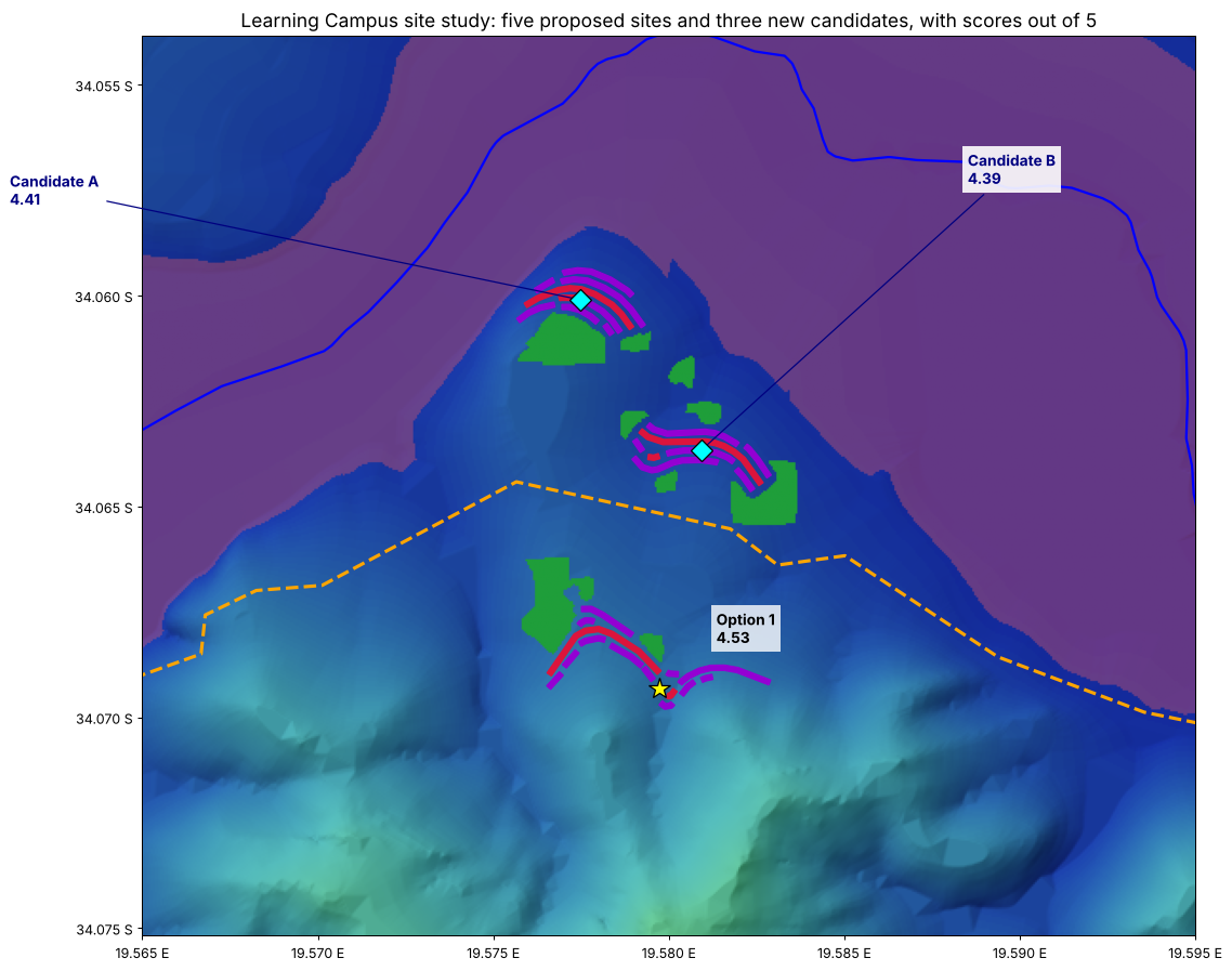
The hill between Genadendal and Greyton, with Option 1 (yellow star) and Candidates A and B (blue diamonds) from the site study. The first line of the bypass (orange) runs between them. Red and purple are the campus buildings, green the gardens.
The idea
A two-lane road about 5.7 kilometres long, on the south bank of the river [MS]. It would leave the R406 on the low ground west of the hill between Genadendal and Greyton, cross a side stream, climb over the shoulder of the hill, and follow the foot of the hills east to the Krige Road [MS]. Most of the route is on Farm 39 (about 4.5 kilometres), and the eastern end is on Erf 595 (about 1.2 kilometres) [MS].
The first line for the road was drawn on the DevForum’s map of the valley’s land [MS]. A desk study then tested it against the national contour map and drew a new line between the same two ends [MS]. The new line was routed to:
- keep the slope of the road to 8% or less wherever the ground allows, a common limit for loaded trucks [TBV]
- stay out of the study’s flood screen wherever it can
- never cross the main river
- keep at least 50 metres from the buildings of every campus site the study looked at.
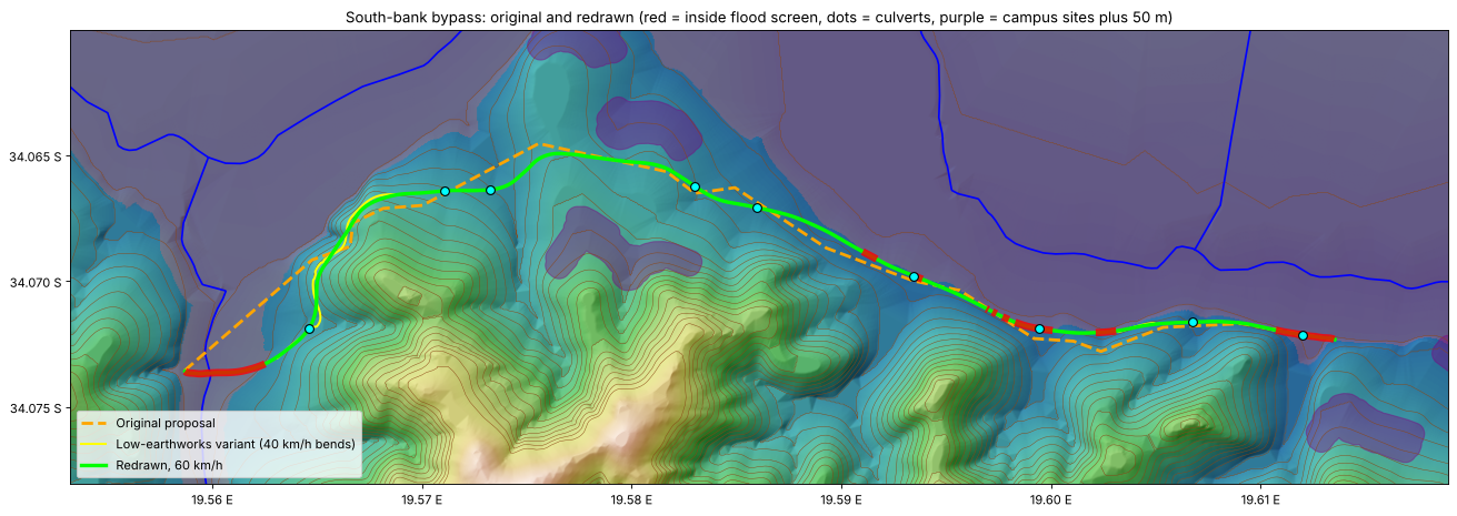
Orange: the first line. Green: the new line for a 60 km/h road. Yellow: a version that follows the ground more closely. Red: where the new line runs inside the flood screen. Blue dots: places where a culvert would be needed. Purple: campus sites, with 50 metres kept clear around them.
What the study found
Two ways to draw the road
The ground forces a choice on the western climb, between the side stream and the shoulder of the hill [MS]. A road with gentle bends needs more digging there. A road that hugs the ground needs less digging, but bends more sharply [MS]. The study drew both [MS]:
| First line | New line, 60 km/h | Version that hugs the ground | |
|---|---|---|---|
| Length | 5.7 km [MS] | 5.7 km [MS] | 5.8 km [MS] |
| Ground steeper than 8% along the route | 1,230 m [MS] | 800 m [MS] | 580 m [MS] |
| Ground steeper than 12% along the route | 310 m [MS] | 280 m [MS] | 40 m [MS] |
| Earth to dig out (cut) | about 27,000 m³ [MS] | about 15,000 m³ [MS] | about 4,000 m³ [MS] |
| Earth to build up (fill) | about 32,000 m³ [MS] | about 17,000 m³ [MS] | about 4,000 m³ [MS] |
| Tightest bend between the two junctions (radius) | about 80 m [MS] | 125 m or more [MS] | about 30 m [MS] |
| Length inside the flood screen | 960 m [MS] | 1,150 m [MS] | 1,110 m [MS] |
| Small streams to cross with culverts | 11 [MS] | 9 [MS] | 9 [MS] |
The earth figures assume an 8 metre wide road, kept to a slope of 8%, with the sides of each cutting and bank sloped at 1 in 1.5 [MS]. They are rough planning figures.
The new line for 60 km/h is the one the study puts forward. It needs about half the earthworks of the first line, and every bend is gentle enough for a truck at 60 km/h, except the turn-offs at each end [MS]. Its biggest earthwork is a bank about 10 metres high over a short stretch, where it rounds the corner onto the western climb [MS].
The version that hugs the ground needs about a seventh of the earthworks [MS]. Its bends on the western climb are tight enough to slow loaded trucks to about 40 km/h [MS].
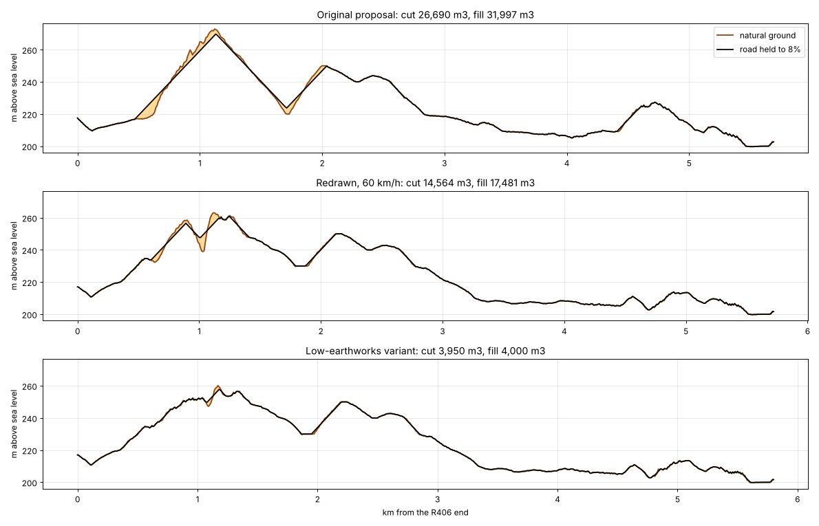
The height of the ground (brown) along each route, from the R406 end on the left to the Krige Road end on the right, and the road kept to a slope of 8% (black). Orange shows where earth would be dug out or built up.
Water and floods
- The road would cross one mapped side stream (number 12100303 on the national river map), near the R406 end [MS]. It would need a bridge or a large culvert. The stream’s catchment reaches beyond the contour map, so its size could not be measured [MS].
- It would cross about nine smaller drainage lines, each draining between about 7 and 100 hectares, which would need culverts [MS].
- About 1,150 metres of the new line falls inside the study’s flood screen [MS]. That is about 370 metres on the low ground at the R406 end, about 270 metres at the Krige Road end, and about 500 metres in the middle, where the road runs along the foot of the hills between 7 and 10 metres above the riverbed [MS]. The first line also ran in these places [MS]. With the slope kept to 8%, the ground leaves no higher route in the middle stretch [MS].
- The flood screen is a rough desk estimate. Only a flood line drawn by an engineer can show which stretches are safe, and which need to be raised on a bank.
Safety
- Drivers would see at least 130 metres ahead in both directions along about half of the route, on the ground as it is now [MS]. Cuttings through the crests would lengthen these views. A speed limit of 60 km/h suits the route better than 80 km/h.
- A school using the road would join it by its own short access road, with a junction placed where drivers on the bypass can see far enough in both directions [MS]. No school building would open onto the bypass.
Who would benefit
- Greyton residents and visitors, if heavy trucks no longer pass through the town’s streets.
- Farmers along the R406 east of Greyton, if the road gives their trucks a shorter or easier route.
- The Learning Campus, if it is built on the hill between Genadendal and Greyton.
Who would pay
Nothing has been costed [MS]. The earthwork figures above are a starting point for a cost estimate. Crossing the streams and raising the low stretches through the flood screen would add to them.
Who would decide
- The land. Farm 39 is held by the national Minister of Land Reform and Rural Development in trust for residents [IC]. The Transformasie Komitee is the community’s mandated body for the land [MS]. Who holds most of Erf 595 has not been established [TBV].
- The road. The R406 is a provincial road [TBV]. Who would build a new road joining it, and who would look after it, has not been discussed with anyone.
- Permissions. Building in or near a watercourse needs an authorisation under the National Water Act [TBV]. A new road may also need an environmental authorisation [TBV]. A change in how Farm 39 land is used falls under the Transformation of Certain Rural Areas Act process [TBV], and land use under the Municipal Land Use Planning By-law [TBV].
How it fits the DevForum’s goal
See Our Long-Term Goal. Most of the road would be on Farm 39 land [MS], and its main stated purpose is traffic going round Greyton [MS]. How Genadendal and Greyton would share its costs and benefits would be for the two communities to decide, through their own bodies.
What is still open
- Whether the road meets its purpose. It only takes trucks off Greyton’s streets if the Krige Road end links back to the R406 east of Greyton, by a road and bridge that trucks can use. The study’s map shows neither the Krige Road nor any bridge.
- The land. The Transformasie Komitee, the Department of Land Reform and the holders of Erf 595 have not been asked.
- The farmers. The farmers whose trucks would use the road have not been asked whether they would use it.
- Which line. The 60 km/h line or the version that hugs the ground, or a mix of the two.
- Floods. Where the 1-in-100-year flood line runs, and how high the road must be on the low stretches.
- The ground. What the soil and rock are like along the route.
- Cost and upkeep. Who would pay to build it, and who would maintain it.
- Fire. Whether the road would also serve as a firebreak or an escape route for the farms and the campus.
What happens next
- The idea is tabled at the DevForum’s November 2026 meeting.
- The Transformasie Komitee, the holders of Erf 595 and the provincial roads authority are asked for their views.
- Someone drives the Krige Road to confirm how it links back to the R406 east of Greyton.
- If the DevForum wants to go further, an engineer walks the route, draws the flood line, and makes a first cost estimate.
Have your say
If you know the Krige Road, the old farm tracks on the south bank, or how trucks move through Greyton today, contact the moderators via How to Submit, or come to the November meeting.
Related
- Where the Learning Campus Could Stand: A Site Study
- Valley of Grace Learning Campus
- Farm 39
- Erf 595, Greyton
- Greyton
- National Water Act
- Ideas for the Valley
References
- DevForum moderators. Google Earth map of the valley’s land. The first line of the road, the Surveyor-General boundaries of Farm 39 and Erf 595, the river lines, and the national contour lines from National Geo-spatial Information (aerial photography of 2007, through the Western Cape Government Spatial Data Warehouse), used to redraw the route.
- DevForum moderators. Learning Campus site study: bypass road check and redrawn route (2 November 2026). The working report and the map file of the redrawn route, held by the moderators.